username
X
password
register
for free!
help


Whites Crossing - Black River, AZ

Guide 2 Triplogs  0 Topics
  5 of 5  
Fav
Wish
1
details
drive
permit
forecast
map
stats
photos
triplogs
topics
location
9 2 0
Statistics
tap row or icons for details
Difficulty 2 of 5
Distance Round Trip 0 miles
Trailhead Elevation 5,900 feet
 Interest Off-Trail Hiking & Perennial Creek
feature photo
Photos Viewed All MineFollowing
2  2012-04-19 Roxyflute5
7  2009-06-27 ssk44
Author
author avatar Guides 16,843
Routes 17,472
Photos 24
Trips 1 map ( 6 miles )
Age 28 Male Gender
Location HAZ, TrailDEX
Associated Areas
list map done
Alpine Region
Historical Weather
Trailhead Forecast
Expand Map
Preferred Apr, Oct, May, Nov
Sun  5:55am - 6:39pm
0 Route
 
0 Alternative


remove free decal offer

  
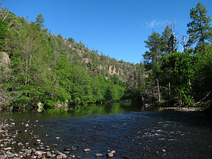
A beautiful segment of the Black River, within the San Carlos Indian Reservation. Activities consist of camping, fishing, and hiking. Hiking this particular river segment is easy to moderate with a defined trail both upstream and downstream. The camping/parking area is located along the river with excellent shade from large ponderosa pine and oak. The recommended route is downstream.


Lat. 33 Degrees/32'/19.93"/N & Long. 109 Degrees/42'/25.63"/W

2018-07-14 HAZ_Hikebot
  • guide related image guide related image
    guide related


Check out the Triplogs.
Leave No Trace and +Add a Triplog after your hike to support this local community.
WARNING! Hiking and outdoor related sports can be dangerous. Be responsible and prepare for the trip. Study the area you are entering and plan accordingly. Dress for the current and unexpected weather changes. Take plenty of water. Never go alone. Make an itinerary with your plan(s), route(s), destination(s) and expected return time. Give your itinerary to trusted family and/or friends.

 Permit $$
San Carlos Indian Reservation Black & Salt River Permit required.
Price, info & locations at San Carlos - Permits


 Directions
or
 Road
High Clearance possible when dry

To hike
From Globe (junction at US60), drive southeast along US70 approximately 24.2 miles to SC-8. SC-8 to Point of Pines is a paved highway. There are NO services of any kind at Point of Pines. Drive along SC-8 for approximately 53.5 mile to SC-4. The turn for SC-4 is just outside of Point of Pines. The remainder of the drive to Whites Crossing is gravel/dirt. If it's raining, be prepared for horrendous mud. The area around Point of Pines can be rather confusing. Keep your eyes open for Black River signs and stay on the main roads.

From the SC-4 turn you will continue east/northeast along SC-8 for approximately 11.8 miles to SC-2008. SC-2008 is an un-maintained high-clearance road. Drive northeast along SC-2008 for approximately 2.5 miles down to the camping/parking area along the river at Whites Crossing. There will be a fork just before reaching the river. Turning right will head to the crossing. See attached topo maps for clarification of the area along SC-2008.

!!WARNING!! Whites Crossing is a remote location, deep within the San Carlos Reservation. The nearest cell phone signal is over 65 miles away. Use caution and discretion during ALL activities. You're on your own!
page created by ssk44 on Jan 21 2010 11:47 am
 90+° 8am - 6pm kills
helpcorrectionissue

end of page marker