 Route Editor

| Guide | ♦ | 16 Triplogs | 0 Topics |
details | drive | no permit | forecast | 🔥 route |
stats |
photos | triplogs | topics | location |
| 113 | 16 | 0 |
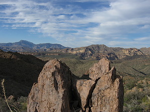
  GET Segment 1 overview GET Segment 1 overviewThe Superstition Wilderness of Arizona's Tonto National Forest encompasses a unique, diverse, and dramatic landscape of canyons, mesas, and volcanic peaks, much of it occurring in the lower and upper Sonoran desert life zones with their equally unique communities of plant and animal life. As such, this first segment of the GET is truly a feast for the senses, a fitting place to begin or end an extended journey on the Grand Enchantment Trail. Our route follows an extensive and meandering network of foot trails, varying in condition from well-trod and easily followable to vague and overgrown in places. The trail sections nearest the significant trailheads (First Water, Peralta, and Rogers Trough) receive the most use. They are maintained accordingly (either officially so or by all the foot and hoof traffic). Farther in the backcountry, where comparatively few users go, trail conditions tend to be rougher and unavoidably overgrown with catclaw and other bushes, at least in corridors here and there. Overall, this segment's terrain is quite rocky and rough, with a fair amount of climbing and descending as the trails negotiate passes between the many steep-walled canyons for which the "Supes" are renowned. For long-distance hikers just starting, rest assured: While the way may seem complicated, and indeed it is unavoidably so here, the rewards are yet evident all around, and the route does become somewhat easier once it joins the Arizona Trail near the eastern end of this segment and continuing into segment 2.
A detailed, mile-by-mile description of this segment is available in the official GET guidebook. See www.grandenchantmenttrail.org This segment of the GET forms part of a longer trip between resupply locations, as described below: GET Segments 1 & 2, Phoenix to Superior The Grand Enchantment Trail begins 45 miles east of downtown Phoenix AZ at the First Water Trailhead in the Superstition Mountains (Tonto National Forest). It follows a foot trail east into this rugged volcanic desert range, winding through lush canyon bottoms and over scenic passes, past saguaro cacti, teddy bear cholla, jojoba, and other highly-adapted plants of the lower Sonoran desert. Weaver's Needle, a dramatic rock fang, is often in view, marking the mythical Lost Dutchman's Gold's location while adding to the real-world grandeur of this landscape. East of sheer-walled Upper La Barge Box, the route climbs toward scenic Horse Ridge and Tortilla Pass, now in the upper Sonoran desert life zone, before descending to follow the rockbound drainage of Rogers Creek and passing near a 700-year-old Salado cliff dwelling. Here the GET joins the Arizona Trail, not far from the gravesite and former ranch of Elisha Reavis, the "hermit of the Superstitions." Following the AZ Trail south, the route climbs chaparral-cloaked Montana Mountain with sweeping views, then drops steeply to follow the drainages of Reavis and Whitford canyons, finally leaving the Superstitions and reaching US Hwy 60 four miles west of the town of Superior nearby the renowned Boyce Thompson Southwestern Arboretum. Check out the Official Route and Triplogs. Leave No Trace and +Add a Triplog after your hike to support this local community. One-Way Notice This hike is listed as One-Way. When hiking several trails on a single "hike", log it with a generic name that describes the hike. Then link the trails traveled, check out the example. | |||||||||||||||||||||||||||||||||||||||||||||||||||||||||||||||||||||||||||||||||||||||||||||||||||||||||||||||||||||||||||||||||||||||||||||||||||||||||||||||||||||||||||||||||||||||||||||||||||||||||||||||||||||||||||


