 Route Editor

| Guide | ♦ | 17 Triplogs | 0 Topics |
details | drive | no permit | forecast | 🔥 route |
stats |
photo | triplogs | topics | location |
| 1 | 17 | 0 |
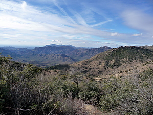
  GET Segment 2 overview GET Segment 2 overviewAlthough not located within officially-designated Wilderness, this segment nonetheless makes for a scenic, interesting, and remote extension southward from Segment 1 toward the very edge of the Superstition Mountains. Section-hikers and very strong weekend hikers may find it convenient to traverse both of these segments in one go, rather than accessing either via the remote, rough-access trailhead at Rogers Trough. Segment 2 begins near the upper elevation threshold of the Sonoran desert, climbs a bit higher, but soon descends rapidly to the low country, touring among lush desert foothills and canyons holding seasonal water. Our route here follows the Arizona National Scenic Trail (AZT) exclusively, most of which is located on singletrack trail, much of it in good condition yet fairly little-used, although you may encounter other hikers, mountain bikers, and equestrians in the second half of this segment, especially on weekends. A detailed, mile-by-mile description of this segment is available in the official GET guidebook. See www.grandenchantmenttrail.org
GET Segments 1 & 2, Phoenix to Superior The Grand Enchantment Trail begins 45 miles east of downtown Phoenix, AZ at the First Water Trailhead in the Superstition Mountains (Tonto National Forest). It follows a foot trail east into this rugged volcanic desert range, winding through lush canyon bottoms and over scenic passes, past saguaro cacti, teddy bear cholla, jojoba, and other highly-adapted plants of the lower Sonoran desert. Weaver's Needle, a dramatic rock fang, is often in view, marking the location of the mythical Lost Dutchman's Gold while adding to the real-world grandeur of this landscape. East of sheer-walled Upper La Barge Box, the route climbs toward scenic Horse Ridge and Tortilla Pass, now in the upper Sonoran desert life zone, before descending to follow the rockbound drainage of Rogers Creek and passing near a 700-year-old Salado cliff dwelling. Here the GET joins the Arizona Trail, not far from the gravesite and former ranch of Elisha Reavis, the "hermit of the Superstitions." Following the AZ Trail south, the route climbs chaparral-cloaked Montana Mountain with sweeping views, then drops steeply to follow the drainages of Reavis and Whitford canyons, finally leaving the Superstitions and reaching US Hwy 60 four miles west of the town of Superior nearby the renowned Boyce Thompson Southwestern Arboretum. Check out the Official Route and Triplogs. Leave No Trace and +Add a Triplog after your hike to support this local community. One-Way Notice This hike is listed as One-Way. When hiking several trails on a single "hike", log it with a generic name that describes the hike. Then link the trails traveled, check out the example. | |||||||||||||||||||||||||||||||||||||||||||||||||||||||||||||||||||||||||||||||||||||||||||||||||||||||||||||||||||||||||||||||||||||||||||||||||||||||||||||||||||||||||||||||||||||||||||||||||||||||||


