 Route Editor

| Guide | ♦ | 29 Triplogs | 1 Topic |
details | drive | no permit | forecast | 🔥 route |
stats |
photos | triplogs | topic | location |
| 388 | 29 | 1 |
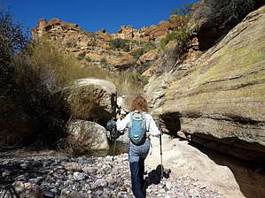
  GET Segment 3 overview GET Segment 3 overviewRelatively small and little-known, yet big on solitude and Sonoran desert charm, the BLM White Canyon Wilderness is the centerpiece of this adventurous segment. Expect to be surprised and impressed with the Superstition-Esque landscapes preserved in this parcel of wildland, but your inspiration here must first be earned. For the hiking is sometimes rugged and primitive, particularly in the Wilderness area itself. The terrain also offers up a healthy dose of elevation gain and loss, with limited access to reliable water. In late 2011 the final miles of the Arizona Trail between Mexico and Utah were completed above the Gila River at the southern edge of the White Canyon area, where a small ceremony was held and a commemorative survey marker installed. The event was a significant milestone in the evolution of that trail, and tacitly for the GET as well. The GET has, and continues to, benefit from ongoing Arizona Trail construction and maintenance, and so it does in this segment. However, the GET has never been beholden to the AZT, and sometimes the two routes might diverge if it's in the best interest of either route to do so. While much of GET Segment 3 follows the route of the Arizona Trail, a portion of it now goes its own way, despite the availability of newly-built AZT trail miles. A further explanation is probably in order.
Elsewhere in this segment, the GET piggybacks enthusiastically onto the Arizona Trail, including many miles of supremely scenic, well-engineered singletrack that is, to be sure, a dream to travel, be it on foot, by horse, or on a bicycle. Together, the two routes pass the Arizona Trail completion marker set trustily into the desert dirt above the banks of the Gila River, a testament to progress. Just be sure to pack along plenty of water, whichever way you go to get here. (As mentioned, potable water - of which the long-journeying Gila here is generally not - is scarce in Segment 3, but thankfully there is one excellent perennial source at an artesian well approximately halfway along. Developed water is also available in the small residential community of Kelvin, half a mile north of the route at the segment's eastern end. See the official GET guidebook and water chart for current information.) A detailed, mile-by-mile description of this segment is available in the official GET guidebook. See https://simblissity.net/get-home.shtml This segment of the GET forms part of a longer trip option between resupply locations, as described below: GET Segments 3 - 5, Superior to Mammoth Continuing southbound along the route of the Arizona Trail (and sometimes apart from it), the GET follows a combination of maintained singletrack and primitive foot trail into the little-known White Canyon Wilderness (BLM), a small but superlative landscape of remnant volcanic peaks and colorful ash-flow sedimentary cliffs. The Sonoran desert here is in fine form, with dense stands of saguaro cacti among a panoply of unique desert flora on display. After a challenging hike along rugged drainages and old mining roads south of the wilderness area, the route rejoins the Arizona Trail alongside the tree-lined banks of the Gila River, where it seeks out a bridged crossing upstream. Beyond, the terrain gradually mellows, and long-range views highlight the distant Sky Island range of the Santa Catalina Mountains near Tucson. Here the route continues to follow an adventurous web of singletrack trail and connecting dirt roads as it seeks out lone Antelope Peak, a low volcanic outlier of the Tortilla Mountains. Eventually, the GET and AZT part ways for good, as our route turns east along the broad sandy course of Putnam Wash in the company of dark basalt cliffs, then along the gentle San Pedro River in a rare desert riparian oasis, to reach AZ Hwy 77 ten miles north of the small village of Mammoth AZ. Check out the Official Route and Triplogs. Leave No Trace and +Add a Triplog after your hike to support this local community. One-Way Notice This hike is listed as One-Way. When hiking several trails on a single "hike", log it with a generic name that describes the hike. Then link the trails traveled, check out the example. | ||||||||||||||||||||||||||||||||||||||||||||||||||||||||||||||||||||||||||||||||||||||||||||||||||||||||||||||||||||||||||||||||||||||||||||||||||||||||||||||||||||||||||||||||||||||||||||||||||||||||||||||||||||||||||||


