| Guide | ♦ | 6 Triplogs | 1 Topic |
details | drive | permit | forecast | route |
stats |
photos | triplogs | topic | location |
| 13 | 6 | 1 |
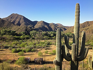
 GET Segment 6 overview GET Segment 6 overviewThe main purpose of this segment is to connect the San Pedro River valley with Segment 7's Aravaipa Canyon Wilderness, which eastbound thru-hikers have no doubt been anticipating. Section hikers arriving by vehicle may be tempted to drive straight to the wilderness trailhead at the east end of this segment, bypassing Segment 6 entirely. Aravaipa Road heads directly there, after all, and with only a few bumps in the track. Look a little closer, though, and one discovers that this segment has a good deal more to offer than at first meets the eye. Formerly routed rather awkwardly in the wide, sandy flood plain of lower Aravaipa Creek's wash, this portion of Seg 6 has since been realigned to provide more efficient and aesthetic-minded travel, much of it on the opposite (north) side of Aravaipa Road and located some miles away from it. Here the route follows a rugged yet straightforward network of little-used dirt tracks leading into surprisingly desert-verdant foothills of the Galiuro Mountains. Primitive camping opportunities, as well as seasonal water, are encountered along the way. Climbing higher, the fiery-hued volcanic cliffs of Brandenburg Mountain, a prominent local landmark, loom near as we transit its western shoulder, while views north and south down the spine of this 50-mile-long Sky Island range prove extensive. Here the route briefly joins foot trail - yes, actual foot trail, albeit humble in character - on return to Aravaipa Road, then soon passes the ranger station for Aravaipa Canyon Wilderness (see Segment 7 description regarding permit requirements for that segment). An hour's ramble along this quiet unpaved portion of the road, often within sight and sound of adjacent Aravaipa Creek, leads to the Wilderness trailhead and the conclusion of Segment 6. After completing this segment - let it be noted - you'll arrive at this trailhead from Highway 77 having accrued nearly identical mileage on your backpack's trip odometer as would any passenger car confined to the main drag. How's that for an efficient hiking route... with an adventurous twist. TRAVEL ALERT: Because this segment (6) ends at the west entrance of Aravaipa Canyon Wilderness, hikers intending to continue eastbound through and beyond the wilderness, and who are unable to obtain the requisite permit to enter this area, should detour around both GET Segments 6 and 7 via the Aravaipa Canyon Wilderness bypass route, as described in the GET online guidebook.
This segment of the GET forms part of a longer trip option between resupply locations, as described below: GET Segments 6 - 11, Mammoth to Safford East of AZ Hwy 77 the Grand Enchantment Trail heads into Sonoran desert foothills of the sky-island Galiuro Mountains, wherein lies the entrance to spectacular Aravaipa Canyon (BLM Wilderness). Sheer canyon walls rise a thousand feet above the lush, deciduous banks of perennial Aravaipa Creek, where we linger, wet feet and broad smiles, for some 12 unforgettable miles. Quiet dirt roads resume east of the canyon, leading within range of the remote outpost of Klondyke - another potential maildrop resupply location - before our route turns northeast to climb into the extreme rugged terrain of the Santa Teresa Wilderness (Coronado National Forest). Little-used trails provide supreme solitude as we navigate the adventurous granite-domed wonderland of Holdout Canyon, then over 7000-foot Cottonwood Mountain near well-named Pinnacle Ridge, and south to reach Klondyke Road. A fun yet challenging cross-country connection culminates at Tripp Canyon, where the GET soon rejoins foot trail to climb high into the forested Pinaleno Mountains (Coronado NF), passing serene Riggs Lake and the viewful fire tower atop 10,000-foot Webb Peak, where snow may linger well into spring. The desert heat seems as far away as the distant horizon atop this tallest of Arizona's Sky Island ranges, where broad panoramas reveal such distinguished neighbors as the Rincons, Huachucas, Chiricahuas, as well as the Mogollon Mountains in New Mexico farther along the GET. Leaving the high country by and by, we follow the magnificent craggy defile of forested Ash Creek Canyon on down toward the open desert nearly a vertical mile-and-a-half below, passing through an astonishing range of life zones in only a few miles of travel. Finally the route joins quiet greasewood-flanked dirt roads to reach the outskirts of bustling Safford, with most services available. Check out the Official Route and Triplogs. Leave No Trace and +Add a Triplog after your hike to support this local community. One-Way Notice This hike is listed as One-Way. When hiking several trails on a single "hike", log it with a generic name that describes the hike. Then link the trails traveled, check out the example. | ||||||||||||||||||||||||||||||||||||||||||||||||||||||||||||||||||||||||||||||||||||||
 Route Editor


