 Route Editor

| Guide | ♦ | 4 Triplogs | 1 Topic |
details | drive | no permit | forecast | 🔥 route |
stats |
photos | triplogs | topic | location |
| 0 | 4 | 1 |
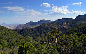
  GET Segment 15 overview GET Segment 15 overviewWhen Spanish explorer Francisco Vasquez de Coronado led his expedition across the Southwest in 1540, he followed a route that ran close by today's Highway 191 from Clifton to Alpine. Coronado came in search of the storied Seven Cities of Cibola - that is, for gold - but today's visitor finds a more enduring treasure along the scenic byway dubbed the "Coronado Trail" - mile after mile of untamed natural splendor. The GET in Segment 15 also passes this way, in turn following a route loosely described by the two-lane mountain highway. Hikers arriving at the Granville Campground trailhead to begin this segment, whether by foot or by vehicle, will already be familiar with the torturous curves for which the Coronado Trail is (in)famous. There are several hundred of them en route to Alpine, the nearest town for northbound touring vehicles. Trading asphalt for dirt, the GET soon rejoins trail of the foot-traffic sort, contouring along the scenic slopes of 7000+ foot summits. Mitchell Peak, a lightly forested crest along a ridge faceted with crests, typifies the complex topography here at the southern edge of the Blue Range, itself only a portion of Arizona's vast Central Highlands region below the Mogollon Rim.
A detailed, mile-by-mile description of this segment is available in the official GET guidebook. See https://simblissity.net/get-home.shtml This segment of the GET forms part of a longer trip option between resupply locations, as described below: GET Segments 15 - 18, Morenci to Alma & Glenwood The jumbled ridges of Arizona's Blue Range unfold northward and the GET contours along their slopes, following foot trail flanked by live oak and manzanita, interspersed with shady conifers and secluded maple groves alive with color in autumn. Views eastward extend to the Mogollon Mountains along our route in New Mexico, and to the nearer canyon system of the Blue River, toward which we now descend. Fording this small river in a remote setting, the wildness of the scene before us is truly written in the sands at creekside, where Merriam's turkey, black bear, and mountain lion leave a telltale trace of their passage. The foot trail resumes en route toward prominent Maple Peak (8000'), from which a vantage of the Blue Range Primitive Area unfolds toward the Mogollon Rim. Descending to reach the Arizona/New Mexico boundary, the GET joins forest roads and heads east through classic New Mexican juniper-grassland toward the small ranching community of Alma, 4 miles north of more tourist-oriented Glenwood. Check out the Official Route and Triplogs. Leave No Trace and +Add a Triplog after your hike to support this local community. One-Way Notice This hike is listed as One-Way. When hiking several trails on a single "hike", log it with a generic name that describes the hike. Then link the trails traveled, check out the example. | ||||||||||||||||||||||||||||||||||||||||||||||||||||||||||||||||||||||||||||||||||||||||||||||||||||||


