 Route Editor

| Guide | ♦ | 3 Triplogs | 1 Topic |
details | drive | no permit | forecast | 🔥 route |
stats |
photos | triplogs | topic | location |
| 75 | 3 | 1 |
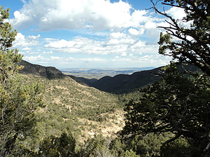
  GET Segment 17 overview GET Segment 17 overviewClimbing over the southernmost ridges of the Blue Range toward New Mexico, our route changes character in this segment. The borderlands here reveal native elements of both Arizona and New Mexico, as though the political boundary were drawn on nature's own terms. Eastbound long-distance travelers will find the familiar trail full of volcanic rocks, the weathered volcanic and sedimentary cliffs, and westward views toward a chaotic and colorful Arizona geography. But a closer inspection also reveals the presence of elk here and turkey - both common to the higher country of New Mexico. And eastward views toward the Land of Enchantment are just as one might imagine, with open, rolling valleys of grassland and juniper rising fluidly toward the high, forested crests at the gateway to Gila country. Our route borders on the Blue Range Primitive Area, one of two sites (along with the Gila National Forest in 1998) selected for their remote, wild character for the reintroduction of the once-extirpated Mexican gray wolf. Although wolves' population is not expanding under current management practices, these majestic predators are undeniably here, perhaps for the very fortunate hiker to hear or even glimpse firsthand. For most of this segment, the GET follows foot trails, remote and little-used other than by hunters in fall, although for the most part followable without a route-finding ordeal. Leaving Wild Bunch Canyon, the route climbs sharply into a complex of narrow, forested ridges - reaching a high point at Maple Peak (8200') - then begins an undulating traverse before descending more moderately toward Sunflower Mesa on the Arizona-New Mexico state line. Water is usually available at one or more small springs in addition to an earthen wildlife tank of fair quality. Finding smooth ground for camping may be a little tricky in this rocky terrain, though one promising location is at Snare Canyon about halfway along.
This segment of the GET forms part of a longer trip option between resupply locations, as described below: GET Segments 15 - 18, Morenci to Alma & Glenwood The jumbled ridges of Arizona's Blue Range unfold northward and the GET contours along their slopes, following foot trail flanked by live oak and manzanita, interspersed with shady conifers and secluded maple groves alive with color in autumn. Views eastward extend to the Mogollon Mountains along our route in New Mexico and to the Blue River's nearer canyon system, toward which we now descend. Fording this small river in a remote setting, the wildness of the scene before us is truly written in the sands at creekside, where Merriam's turkey, black bear, and mountain lion leave a telltale trace of their passage. Foot trail resumes en route toward prominent Maple Peak (8000'), from which a vantage of the Blue Range Primitive Area unfolds toward the Mogollon Rim. Descending to reach the Arizona/New Mexico boundary, the GET joins forest roads and heads east through classic New Mexican juniper-grassland toward the small ranching community of Alma, 4 miles north of more tourist-oriented Glenwood. Gate Policy: If a gate is closed upon arrival, leave it closed after you go through. If it is open, leave it open. Leaving a closed gate open may put cattle in danger. Closing an open gate may cut them off from water. Please be respectful, leave gates as found. The exception is signage on the gate directing you otherwise. Check out the Official Route and Triplogs. Leave No Trace and +Add a Triplog after your hike to support this local community. One-Way Notice This hike is listed as One-Way. When hiking several trails on a single "hike", log it with a generic name that describes the hike. Then link the trails traveled, check out the example. | |||||||||||||||||||||||||||||||||||||||||||||||||||||||||||||||||||||||||||||||||||||||||||||||||||||||||||||||


