This segment of the GET forms part of a longer trip option between resupply locations, as described below:
GET Segments 22 - 27, Gila Hot Springs to Monticello
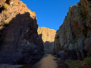
The Grand Enchantment Trail continues its water-blessed way through the majestic Gila Country of New Mexico, first along the Middle Fork Gila River, then climbing above its canyon to cross open mesas toward a meeting with the Gila's gentler East Fork as well as Diamond Creek, a prime tributary. Foot trails, both maintained and informal, continue to allow nearly seamless travel as the route enters park-like Tom Moore Canyon. Here an adventurous side trip gains access to an enticing slot canyon, while the GET strides more easily in open ponderosa forest - prime elk habitat - ascending gradually toward amusingly named Me Own Hill. A short switchbacking descent next accesses the verdant canyon bottom of South Diamond Creek, where our route begins a final climb toward the Continental Divide. Views abound on the Black Range Crest near 9800' Diamond Peak, from which the Continental Divide Trail leads north for several miles of well-graded ridgewalking, while young aspens lend spectacular fall color in numerous old burns along the way. To the north the Divide mellows and ponderosas take hold once more as the GET/CDT tours on purpose-built trail tread. After 45 serene but sometimes droughty miles, the GET leaves the Continental Divide near Wahoo Peak to head east, clambering downhill to the Gila National Forest boundary, where we exit the forest some 140 miles from our entrance near Glenwood. Dirt roads and brief, optional cross-country travel then lead through rolling juniper-yucca desert toward the entrance to Monticello Box Canyon and Ojo Caliente (Warm Spring), the area still sacred to Apaches whose ancestors once called this land home. Beyond, the GET follows the perennial waters of Alamosa Creek to within 10 miles of the peaceful hamlet of Monticello and an important resupply opportunity.
When hiking several trails on a single "hike", log it with a generic name that describes the hike. Then link the trails traveled, check out the example.
WARNING! Hiking and outdoor related sports can be dangerous. Be responsible and prepare for the trip. Study the area you are entering and plan accordingly. Dress for the current and unexpected weather changes. Take plenty of water. Never go alone. Make an itinerary with your plan(s), route(s), destination(s) and expected return time. Give your itinerary to trusted family and/or friends.
Permit $$
None
Directions
Road
High Clearance possible when dry
To hike From Albuquerque:
Follow I-25 S 138 mi to NM-181 S in Sierra County. Take exit 89 from I-25 S
Follow NM-181 S 2.9 mi then turn right onto paved NM-52 N
In ~31 mi. from I-25, reach community of Winston (last gas station). Continue ~10 more mi. and turn left onto paved NM 59.
In ~5 mi. turn right (north) onto dirt FR 913 and follow this road ~10 mi. to t-junction just before cattle guard and turn left. (USFS boundary reached 0.2 mi. beyond if missed this junction.)
Keep left at next fork and continue 0.25 mi. to unsigned trailhead turnout for Trail 60 at road's end. (Please note: No vehicle access to this point from Dusty / NM 52 due to locked gates.)
page created by HAZ_Hikebot on Jun 26 2014 6:43 pm
 Route Editor


