This segment of the GET forms part of a longer trip option between resupply locations, as described below:
GET Segments 28 - 31, Monticello to Magdalena
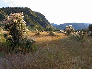
The bold, talus-strewn profile of the San Mateo Mountains looms ahead as the GET follows a lonely track known as the Burma Road among folded juniper-grassland hills. Ahead, the rugged defile of Shipman Canyon offers access to the Cibola National Forest and Apache Kid Wilderness. Infrequently visited and providing one of the finest high-elevation wilderness experiences along the route, the Apache Kid also provides refuge for mountain lion and black bear, the latter in increasing numbers. These mountains once legendarily offered human ensconcement as well, and our route passes near the final resting place of the wanted outlaw called Apache Kid, high on the 10,000-foot crest of the range. Scenery and solitude abound as we head north along the rugged ridge, joining the adjacent Withington Wilderness to explore a pair of fire lookouts, including Mt Withington's (10,100') with views of the vast Plains of San Agustin below and first glimpses of the Sandia Crest ahead near Albuquerque. The drainage of Potato Canyon reveals fascinating volcanic geology as the GET descends east off the crest, back onto the high desert to follow jeep tracks and cross-country canyons in search of our next Sky Island range, the Magdalena Mountains. Here, a rugged ascent leads to one of the finest ridgeline walks on the entire route, with open, alpine-like terrain near South Baldy (10,783'), frequent meadows, and a knife edge traverse. The Langmuir lightning research facility is located here as well, alongside the Magdalena Ridge Observatory, an ultra-high-resolution telescope array currently under development. Finally the GET returns to high-desert country again near the famed ghost town of Kelly, 3 miles south of historic Magdalena and our next wayside along the route.
When hiking several trails on a single "hike", log it with a generic name that describes the hike. Then link the trails traveled, check out the example.
WARNING! Hiking and outdoor related sports can be dangerous. Be responsible and prepare for the trip. Study the area you are entering and plan accordingly. Dress for the current and unexpected weather changes. Take plenty of water. Never go alone. Make an itinerary with your plan(s), route(s), destination(s) and expected return time. Give your itinerary to trusted family and/or friends.
Permit $$
None
Directions
Road
High Clearance possible when dry
To hike From Albuquerque, NM:
Follow I-25 S to US-60 W/California St in Socorro. Take exit 150 from I-25 S
77.3 mi
Continue on US-60 W
27.0 mi
Turn left onto graded dirt NM-107 S
17.0 mi
Turn right onto Forest Rd 52
3.3 mi
Turn left onto Forest Rd 56 (high-clearance recommended)
2.1 mi
Trailhead for Potato Trail #38 is on the right.
page created by HAZ_Hikebot on Jun 22 2014 10:26 pm
 Route Editor


