This segment of the GET forms part of a longer trip option between resupply locations, as described below:
GET Segments 32 & 33, Magdalena to Mountainair
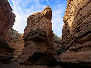
A variety of desert environments provide exhilarating open-air walking as the Grand Enchantment Trail extends northeastward from Magdalena. North of US Hwy 60 the route makes use of forest roads on a brief tour of the Bear Mountains, then crosses the wide juniper-grassland valley of La Jencia Creek via an enjoyable network of primitive 2-tracks and cross-country travel. Ladron Peak, wild and little-explored, stands sentinel on the distant horizon, while ahead lies the smaller Polvadera range, which we approach, watching for herds of pronghorn antelope, before descending to reach San Lorenzo Canyon. Here the route follows a sandy wash into a colorful, sheer-walled box canyon, with several labyrinthine slots available for exploration, then reaches the fertile Rio Grande valley and a resupply option at tiny Polvadera (or larger Socorro). The GET winds through the Rio Grande bosque, or "riverside woods," fording the wide, often shallow river (high water detour available), then proceeds back into the Chihuahuan desert, where cross-country travel and lonely 2-track roads lead past intriguing mesas and unnamed desert peaks. Our tour of this little-known region culminates again at Hwy 60, here 18 miles west of Mountainair, a small ranching town offering basic provisions.
When hiking several trails on a single "hike", log it with a generic name that describes the hike. Then link the trails traveled, check out the example.
WARNING! Hiking and outdoor related sports can be dangerous. Be responsible and prepare for the trip. Study the area you are entering and plan accordingly. Dress for the current and unexpected weather changes. Take plenty of water. Never go alone. Make an itinerary with your plan(s), route(s), destination(s) and expected return time. Give your itinerary to trusted family and/or friends.
Permit $$
None
Directions
Road
Paved - Car Okay
To hike From Albuquerque, NM:
Follow I-25 S to US-60 W/California St in Socorro. Take exit 150 from I-25 S
77.3 mi
Continue on US-60 W
26.0 mi
Parking available in the town of Magdalena
page created by HAZ_Hikebot on Jun 23 2014 7:58 pm
 Route Editor


