This segment of the GET forms part of a longer trip option between resupply locations, as described below:
GET Segments 34 - 37, Mountainair to Tijeras
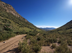
The Abo District of Salinas Pueblo Missions National Monument makes for a worthwhile detour along US Hwy 60. Northward, the GET explores a series of secluded sandstone arroyos, often with spring pools, then ascends via 2-track to a pinyon-juniper forested plateau at the foot of the Manzano Mountains. A well-worn forest road leads a half hour or so to Pine Shadow Trailhead, where our route joins foot trail, climbing sharply to Manzano Peak (10,098') at the southern end of the fault-block range. Here begins a memorable 2 day traverse of the Manzano Crest Trail, as we wind along an extraordinary ridge, over summits clad in spruce and fir, through aspen-blessed meadows, and along the edge of a sheer limestone "reef," often within sight of the vast Rio Grande valley below. The Manzano Hawk Watch site is here, an ideal vantage from which to view raptors along this important migration corridor. Black bear are commonly seen among the forests and meadows, and especially near Capilla Peak Campground, a popular retreat along the way. Finally our route descends eastward, leaving the Manzano Wilderness and, at Canon Tajique, entering a lush forest of Rocky Mountain large-tooth maples, crimson in fall and among the finest such groves in all of New Mexico. Regaining the Cibola National Forest at meadow-blessed David Canyon, foot trails lead us north toward Otero and Cedro canyons, the latter representing a significant riparian habitat success story here at the wildland-urban boundary. A brief climb to the juniper-cloaked flanks above Tunnel Canyon rewards with sweeping views of looming Sandia Crest. A short roadwalk then leads into Tijeras, located along old Route 66, and offering a final maildrop option for Albuquerque-bound thru-hikers.
When hiking several trails on a single "hike", log it with a generic name that describes the hike. Then link the trails traveled, check out the example.
WARNING! Hiking and outdoor related sports can be dangerous. Be responsible and prepare for the trip. Study the area you are entering and plan accordingly. Dress for the current and unexpected weather changes. Take plenty of water. Never go alone. Make an itinerary with your plan(s), route(s), destination(s) and expected return time. Give your itinerary to trusted family and/or friends.
Permit $$
None
Directions
Road
FR / Dirt Road / Gravel - Car Okay
To hike From Albuquerque, NM:
Follow I-25 S
31.6 mi
to I-25BUS in Belen. Take exit 195 from I-25 S
3.9 mi
Turn right onto N Main St
0.2 mi
Turn left onto W Reinken Ave
1.1 mi
Continue onto NM-309 W/E River Rd
1.3 mi
Turn right onto NM-47 S/Rio Communities Blvd
Continue to follow NM-47 S
19.2 mi
Turn left onto US-60 E
2.8 mi
Turn right onto graded dirt county road B 115 / Augies Ranch Rd. Pass through swinging gate (please close & latch behind you) and park on an abandoned section of road at right (old Hwy 60 alignment).
page created by HAZ_Hikebot on Jun 23 2014 10:02 pm
 Route Editor


