 Route Editor

| Guide | ♦ | 5 Triplogs | 0 Topics |
details | drive | permit | forecast | map |
stats |
photos | triplogs | topics | location |
| 62 | 5 | 0 |
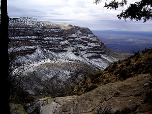
This Dog Don't Bark! by imike Dog Point, the destination of this hike, is the highest point above those towering cliffs on the north side of the canyon (on your left as you hike up the canyon). Though it does not stand out as a visible high point from anywhere on the trail, it is impressive to imagine that you are headed to a point that towers above the very cliffs towering above you during the lower portion of this hike. Dog Point, really an unnamed highpoint on the map, is the 7753' high point along Joplin Ridge, and offers a 360 degree view of that mountain section. To the west lies the Tularosa Basin and the outstanding White Sands National Monument. To the north lies the San Andreas Canyon drainage. To the east, the inner valley that separates the frontal range from the upper range is exposed for miles. To the south, across the Dog Canyon Drainage, can be seen Gobbler Knob, the high point over the next drainage: Escondido Canyon. It is truly a Panoramic view.
You will note on your left during this final section that you are now simply retracing your path over the long meadow you crossed between mile 4.5 and mile 5... just a few hundred feet below you. A consideration for alternative route on your way up is to depart the main trail at mile marker 4.5 and head directly up the hill to the north (left) and skip that extra bit of mileage, although it is a pretty section. I would definitely use the direct downhill route on the return trip unless you just want that extra mileage. This is a great easy day out/back destination hike. In the winter, the meadow above 6,000' can be snow covered. Take proper gear. The peak can be accessed by ATV from above. Forest Road 90 (West Side Road) provides access to the entire frontal range from that 7500' level. Check out the Triplogs. Leave No Trace and +Add a Triplog after your hike to support this local community. One-Way Notice This hike is listed as One-Way. When hiking several trails on a single "hike", log it with a generic name that describes the hike. Then link the trails traveled, check out the example. | ||||||||||||||||||||||||||||||||||||||||||||||||||||||||||||||||||||||||||||||||||||||||||||||


