Route Editor

| Guide | ♦ | 8 Triplogs | 1 Topic |
details | drive | permit | forecast | map |
stats |
photos | triplogs | topic | location |
| 38 | 8 | 1 |
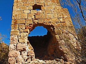
 Overview OverviewSeveral Silver mines in this area created a frenzy of activity and building. Hike the remains of Denoon and the Reymert area and washes to find signs of activity and foundations from the settlements here in the 1890s. Access to the trailhead involves crossing State Land(permit required), BLM land, and Tonto National Forest (both not requiring a permit). The historic Silver Smelter still stands. Tailings from old mine sites line the canyon. There is still an active mine one mile east of this location, which prevents this from being a side excursion for the Arizona Trail. Check out the Triplogs. Leave No Trace and +Add a Triplog after your hike to support this local community. | |||||||||||||||||||||||||||||||||||||||||||||||||||||||||||||||||||||||||||||