Route Editor

| Guide | ♦ | 13 Triplogs | 0 Topics |
details | drive | no permit | forecast | map |
stats |
photos | triplogs | topics | location |
| 10 | 13 | 0 |
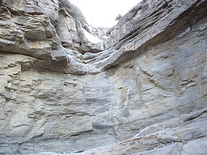
Canyons are inherently risky. Flash floods occur without notice on sunny days. Technical skills & surrounding topography knowledge required yet does not eliminate risk.
Down and Low... by imike  This will be a longer effort, extremely steep once you make the move to work up to the ridge. Depending on your return option, you could also log some very long mileage, and if you opt to return down "A" it may feel like an overly steep effort for the end of the day.
For variety, hiking this drainage cut is a great bit of entertainment. As described in the hike for Ortega Peak, this approach is up the northern cut of this drainage. During the first mile of this hike, look for a slick rock fall side drainage on your left, and climb that short falls to enter the drainage... and don't exit until you reach the end, where you'll climb out as you see fit. Check out the Triplogs. Leave No Trace and +Add a Triplog after your canyon trip to support this local community. | |||||||||||||||||||||||||||||||||||||||||||||||||||||||||||||||||||||||||||||||||||||||||||