 Route Editor

| Guide | ♦ | 12 Triplogs | 0 Topics |
details | drive | no permit | forecast | map |
stats |
photos | triplogs | topics | location |
| 25 | 12 | 0 |
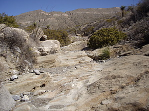
It's the then some that makes It! by imike  The way to find this hike is to head off from the trailhead moving up the hill past the levee, keeping Indian Wells Road in sight. Effectively, the jeep track you want is the one that lines up right with Indian Wells where the old pipeline cut (north/south jeep road) crosses that line. It is easy to spot this cut; there is a major wash on the north side of the jeep track with huge exposed water lines. You may also access this hike by simply following the route of the other west bound jeep track up to the "party place" waterfall, dropping into that drainage and hiking up it until it intersects the jeep road up above. Additionally, instead of hiking the jeep road, feel free to drop off into the drainage on either side of the jeep road and enjoy the nice drainage hiking. You can return to the road further up.
Expect to find numerous nice picnic areas, even shaded alcoves. If you simply glance at the map, it seems a little pointless to make the effort. On the contrary, when used to create a simple loop down Lost Trail, or up Lost Trail to Ortega... then with the option of a fast drop down T119, this trail provides for a great day out from the city. Note: there is a hike between Mineral Springs and Lost Trail, Little Mineral Springs Trail... that is often mistaken for Mineral Springs trail, very easy to do when hiking from the bottom. It is a nice hike, but it does deadend, although you could cut cross country up to Mineral Springs trail, hiding up above. Check out the Triplogs. Leave No Trace and +Add a Triplog after your hike to support this local community. One-Way Notice This hike is listed as One-Way. When hiking several trails on a single "hike", log it with a generic name that describes the hike. Then link the trails traveled, check out the example. | ||||||||||||||||||||||||||||||||||||||||||||||||||||||||||||||||||||||||||||||||||||||||||


