|
tap row or icons for details
|
| Difficulty |
|
3.5 of 5 |
| Distance One Way |
|
5.6 miles |
| Trailhead Elevation |
|
3,317 feet |
| Elevation Gain |
|
1,385 feet |
| Accumulated Gain |
|
1,923 feet |
| Kokopelli Seeds |
|
12.01 |
| Interest Off-Trail Hiking, Historic, Seasonal Waterfall, Perennial Waterfall & Seasonal Creek | | unreported if dogs are allowed
editedit > ops > dogs to adjust |
| | |
|
|
4 |
2018-02-04 | Roninthedog |
|
|
21 |
2018-02-01 |
Silver king mine/stoneman grade |
jameslcox44 |
|
|
|
1 |
2012-12-20 | bmbeard |
|
|
26 |
2012-02-26 |
|
|
|
8 |
2010-10-27 | AZLOT69 |
|
|
14 |
2010-10-25 | AZLOT69 |
|
|
13 |
2010-02-18 | AZLOT69 |
|
| |
|
|
list |
map |
done |
Globe Region |
| | |
|
| |
|
|
Historical Weather |
| Trailhead Forecast | | |
|
 |
|
|
| Preferred Nov, Mar, Apr, Feb |
|
|
| | |
Named Locations Coordinate Links
| |
|
| Stoneman Grade
|
3.47 mi
738 ft |
|
|
| Quarry To Stoneman Grade Trailhead
|
0.6 mi
187 ft |
|
|
| FR 342 to Quarry for access to St...
|
7.12 mi
1,910 ft |
|
|
| | |
| |
|
|
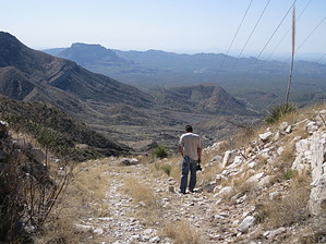
Overview
Historic Stoneman Grade which was the first trail connecting the Superior area to Globe in the late 1880's.
One-Way NoticeThis hike is listed as One-Way. When hiking several trails on a single "hike", log it with a generic name that describes the hike. Then link the trails traveled, check out the example. |
 Route Editor


