Overview: "Echo Canyon" is the longest canyon in the Funeral Mountain Range of DVNP. This canyon is very scenic and appeals to both hikers and 4WD interests. The lower canyon is a gorge that starts right away at the mouth and continues with varying degrees of tightness with depth and high walls where the echo is good. There are several windows in this gorge, most residing high-up from the canyon floor. The most striking one is the "Eye of the Needle", a triangular, 15-foot tall opening pierced 50 feet above the wash in a narrow section of a tight bend in this wash road (~4.8 miles in at way point N36.46712 W-116.75996). At sunset, this is the place to be for an excellent opportunity for a great pic of the setting sun as it produces a strong beam of light through the "Eye of the Needle" contrasted by nightfall.
At the TH Parking area 9.50 miles in, is the well know "Inyo Mining Camp" which is a cluster of a half dozen wooden houses at the foot of a steep hillside where gold was once mined. It is one of the most scenic mining camps in the park, and one of the very few large enough to qualify as a ghost town. The main Inyo mines are high on the hillside behind the camp complex and reached by a visible steep, rocky trail.
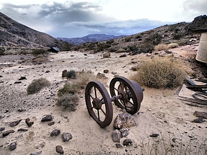
The very interesting "Furnace Mine Complex", the site of the last mining effort of 1940-41, is about .5 mile NE of the last high Inyo Mine shaft on the far side of the ridge. A fairly good use trail will take you to this site. This is an intriguing complex, a repository of obsolete machinery well worth the extra effort of the climb.
WARNING! Hiking and outdoor related sports can be dangerous. Be responsible and prepare for the trip. Study the area you are entering and plan accordingly. Dress for the current and unexpected weather changes. Take plenty of water. Never go alone. Make an itinerary with your plan(s), route(s), destination(s) and expected return time. Give your itinerary to trusted family and/or friends.
Permit $$
NPS
Directions
Road
High Clearance possible when dry
To hike From Furnace Creek,CA: From the intersection of SR190/Badwater Rd(SR178), drive 2.1 miles east on SR190 to a high clearance, primitive road on your left(north) marked by an inconspicuous sign (way point N36.43755 W-116.82420); Here turn left(north) on to Echo Canyon Road and continue along this rough, sometimes deep gravel road for 9.50 miles to the Inyo Mines Camp TH/Parking area for the Inyo Mines hike and the further Furnace Mine Complex (TH Parking at way point N36.49338 W-116.70386); Also reference GPS Driving Route to Echo Canyon-Inyo Mines/Furnace Mine TH/Parking posted to this hike description;
page created by Grasshopper on Feb 21 2010 8:03 pm
 Route Editor