Canyons are inherently risky. Flash floods occur without notice on sunny days. Technical skills & surrounding topography knowledge required yet does not eliminate risk.
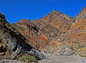
Overview: Located in the southwestern Cottonwood Mountains resides this popular canyon for pic taking, day hikeing, and backpacking. If you like marble, narrows, rock art, or all, put Marble Canyon high on your list. It is claimed that the ancient petroglyphs that adorn the canyon walls (both on the drive in and hike) rank among the most elaborate and extensive in all of Death Valley. As of this writing for my posted trip log dated 2/13/10, our hiking group only viewed a couple of petroglyph panels located ~2.0mls to 2.2mls in at way point N36.60982 W-117.34316;
This hike description takes you through the most scenic Lower Marble Canyon Narrows #1 & #2 (ending at 1.6 miles in). There are actually three narrows, the 3rd starting at 4.0 miles in. We hiked in to a stopping point at 3.2 miles in. Unless you are planning a backpack trip through this 10.7 mile canyon to end at Goldbelt Spring- Camp/Road, I recommended that you day hike in to the above mentioned petroglyph panel site and then turn back.
WARNING! Hiking and outdoor related sports can be dangerous. Be responsible and prepare for the trip. Study the area you are entering and plan accordingly. Dress for the current and unexpected weather changes. Take plenty of water. Never go alone. Make an itinerary with your plan(s), route(s), destination(s) and expected return time. Give your itinerary to trusted family and/or friends.
Permit $$
NPS
Directions
Road
High Clearance possible when dry
To canyon trip From Stovepipe Wells, CA: On SR190 through this small town in DVNP, "to the left" of the Stovepipe Wells Campground entrance, turn north on to Cottonwood Canyon Road (way point N36.60590 W-117.14758); Continue on this primitive road for ~8.6+ miles until it veers northwest (left turn); From here the road continues up Cottonwood Wash heading west then south for ~2.2 miles to the easy to miss intersection with Lower Marble Canyon west(right turn at small street type sign); Continue west, then south for ~2.6 miles into the beginning of the first narrows of Lower Marble Canyon and Parking/TH Start at way point: N36.61876 W-117.33049 (Also see GPS Route Driving Directions posted to this Hike Description);
page created by Grasshopper on Feb 22 2010 5:32 pm
 Route Editor