 Route Editor

| Guide | ♦ | 13 Triplogs | 1 Topic |
details | drive | permit | forecast | map |
stats |
photos | triplogs | topic | location |
| 105 | 13 | 1 |
I know where I am...Right? by imike Additionally, the display details the portion of the White Sands basin that is off limits, not open to hiking except with prior approval. This is the Cooperative Use Zone area (all lands west of 106 degrees 20 minutes West Longitude). I get the feeling that if you venture over into that area you might become a ready and inviting moving target for the adjacent missile range folks, or the German Airforce housed at Holloman Air Base on the upper end of the Monument.
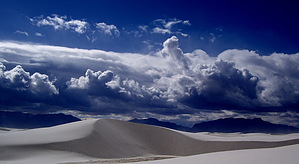
Once signed in and aware of where you cannot go, decide generally where you would like to explore, or, just head out across the dunes. The surrounding mountains provide a solid orientation for a general sense of navigating. The erosion patterns are not reliable... they are formed by wind, not water, so the little valleys tend to lead to nowhere. Seek out the tallest dunes for a sense of progress... and it is deceiving as to exactly which are the big ones... they all loom large from one perspective or another. Cooler weather, or a cloudy day makes for the best adventuring. The park does not open until 7am, so early starts are a bit hard to achieve unless you take advantage of their tent camping areas... spending the night out. They effectively discourage this activity by putting the limited sites well away from the road (...bit odd since the park is locked down at night!) but, this nearly guarantees you may have the park to yourself... and can begin your early morning adventuring whenever you want... or even better, choose a full moon night and venture out for an overnight hike. I normally would suggest foregoing a GPS out in the dunes... takes away some of the alure, but it sure can make it easy to find your camp or car at the end of the day. And, in the event of a sand storm (...a real potential) can be a lifesaver. White Sands off trail... the only way to go! Check out the Triplogs. Leave No Trace and +Add a Triplog after your hike to support this local community. One-Way Notice This hike is listed as One-Way. When hiking several trails on a single "hike", log it with a generic name that describes the hike. Then link the trails traveled, check out the example. | |||||||||||||||||||||||||||||||||||||||||||||||||||||||||||||||||||||||||||||||||||||||||||||||||


