 Route Editor

| Guide | ♦ | 6 Triplogs | 0 Topics |
details | drive | no permit | forecast | route |
stats |
photos | triplogs | topics | location |
| 41 | 6 | 0 |
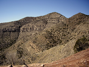
Save This Hike for Later! by imike  The local hiking guide does not address these issues; it focuses on the simple issue of the views to be had once down to the ridge line, labeling them the best to be found in the entire area. That statement is what eventually got me to head on down the hill, and I have to admit there is something outstanding about the vista. You look out over Hells Hole and up at Hershberger Peak and it is impressive. There is also a very odd greenish hue to the entire setting making it somewhat other worldly.
If you'd like to hike from Alamogordo, take "A" (#119) trail up to Ortega Peak, then over to Hershberger Peak, and as you descend east, you'll hit that same intersection with T5574 and T219... at about five miles. This route has the advantage of having the over 3,000' of climbing up "A" trail and will make the day worth doing. If you are feeling adventurous and would like to have a great off trail experience, hike on past the end of trail sign on #219, over to the old mine works, and drop into the washed out drainage heading down to Caballero Canyon. Make your day into a nice looping event back to town. This Caballero/Hershberger Traverse route in the drainage to the east of Hells Canyon drainage is a gem of a hike. Check out the Official Route and Triplogs. Leave No Trace and +Add a Triplog after your hike to support this local community. One-Way Notice This hike is listed as One-Way. When hiking several trails on a single "hike", log it with a generic name that describes the hike. Then link the trails traveled, check out the example. | |||||||||||||||||||||||||||||||||||||||||||||||||||||||||||||||||||||||||||||||||||||||||


