Black Rock Short Loop - White Tanks, AZ | HikeArizona
username
X
password
register
for free!
help
  

Black Rock Short Loop - White Tanks, AZ

Guide 15 Triplogs  0 Topics
  2 of 5 
Fav
Wish
0
details
drive
permit
forecast
route  
stats
photos
triplogs
topics
location
0 15 0
Statistics
tap icons for details
Difficulty 1 of 5
Distance One Way 0.5 miles
Trailhead Elevation 1,461 feet
Elevation Gain 68 feet
Accumulated Gain 68 feet
Avg Time One Way 0.25 hours
Kokopelli Seeds 0.73
feature photo
Photos Viewed All MineFollowing
15  2019-09-28
Ironwood Trail-Waddell Trail
RowdyandMe
29  2019-04-03
Black Rock Trail-Waterfall Trail
RowdyandMe
20  2015-03-02
Black Rock Long Loop - White Tanks
Stoic
1  2014-04-27
Black Rock Long Loop - White Tanks
trekkin_gecko
Author
author avatar Guides 7
Routes 0
Photos 216
Trips 41 map ( 212 miles )
Age 46 Male Gender
Location Boulder, CO
Associated Areas
list map done
Phoenix Region
Historical Weather
Trailhead Forecast
Radar Map
Expand Map
Preferred Feb, Jan, Dec, Nov
Sun  6:56am - 6:28pm
Official Route
 
3 Alternative
 
 Water


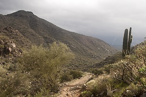
Itty Bitty peaceful easy feeling
by ferazamboni

Overview
The black rock loops (short and long) are very easy trails that offer an up-close look at the various desert plant and wildlife in the White Tank Mountain Regional Park. The short loop is only 0.5 miles long, while the long loop tops out at 1.3. Along both loops are information panels that provide information about plants and wildlife in the area.


I have hiked in this area many times, and I rarely see people on the Black Rock Loop trails. This may be because these trails seem too easy for most hikers.

I'm not positive, but I'll guess they named this the "Black Rock" loop because of the hills of large "dark brown" boulders that are located to the South of the trail. I'm not sure you would even get to see these up close unless you take the long loop.


If you want a perfect short hike in this park, you should combine the Black Rock Long Loop with the Waterfall Trail. I'm not sure why more hikers don't do this. It just makes sense. Instead, everyone seems to crowd the Waterfall Trail trailhead.

So if you want some peace and quiet before hitting the Waterfall trail, start on the Black Rock Long Loop trail. When you return from the Waterfall trail, make sure you don't miss the junction back onto the Black Rock trail at the Ramada. Why the park does not have a sign for this junction baffles me. On the way back be sure to "complete" the loop. If you do this you'll come closer to the "black rocks".

Check out the Official Route and Triplogs.

Leave No Trace and +Add a Triplog after your hike to support this local community.

2004-12-04 ferazamboni
  • S_WhiteTanks.png S_WhiteTanks2.png S_WhiteTanks3.png
    guide related
  • 2019 White Tank Trails Map
    area related
    2019 White Tank Trails Map
  • 2019 White Tanks Closeup Map
    area related
    2019 White Tanks Closeup Map

One-Way Notice
This hike is listed as One-Way.

When hiking several trails on a single "hike", log it with a generic name that describes the hike. Then link the trails traveled, check out the example.
WARNING! Hiking and outdoor related sports can be dangerous. Be responsible and prepare for the trip. Study the area you are entering and plan accordingly. Dress for the current and unexpected weather changes. Take plenty of water. Never go alone. Make an itinerary with your plan(s), route(s), destination(s) and expected return time. Give your itinerary to trusted family and/or friends.

 Permit $$
Maricopa Regional Parks - 2021 [ fees ]

$7 per vehicle,$85 annual or trade your first born for the life pass

$2 walk, bike or horse ride into park

2021 [ hours ] - varies by park & season


 Directions
or
or
 Road
Paved - Car Okay

To hike
101 Loop to Park Take the I-10 west out of Phoenix to the 101 Loop Freeway. Go north on the 101 to Olive Blvd. Take a left and head west 13.5 miles to the White Tanks park entrance.

I-10 to Park To get to the White Tanks Park from downtown (PHX) is to stay on I-10 to Cotton Lane. Then go North 7 miles to Olive Ave, there is a stop sign and a Fertazone plant on the NW corner. Take a left (west) to the park. By going this you miss the new stoplights and the added stop signs on Olive.

Once in the park... (need clarification from here) for now get directions at the information center.
page created by HAZ_Hikebot on Mar 06 2010 10:52 pm
helpcorrectionissue

end of page marker