username
X
password
register
for free!
help
  

Cockscomb Trail - Sedona, AZ

Guide 20 Triplogs  0 Topics
  3.1 of 5  
Fav
Wish
3
details
drive
permit
forecast
route  
stats
photos
triplogs
topics
location
103 20 0
Statistics
tap row or icons for details
Difficulty 2 of 5
Route Finding 2 of 5
Distance One Way 3.5 miles
Trailhead Elevation 4,582 feet
Elevation Gain -75 feet
Accumulated Gain 293 feet
Avg Time One Way 1.5 hours
Kokopelli Seeds 4.48
 Backpack No
feature photo
Photos Viewed All MineFollowing
Inaugural Calculation on Button Tap!
16  2015-05-03 rrshort
24  2012-03-25
Doe Mountain Loop
rwstorm
12  2012-03-25
Doe Mountain Loop
cindyl
16  2009-04-27 hippiepunkpirate
10  2008-04-11 slegal
7  2008-03-26 slegal
14  2007-02-18 slegal
4  2000-04-13 joebartels
Author
author avatar Guides 9
Routes 28
Photos 211
Trips 20 map ( 96 miles )
Age 88 Male Gender
Location Sedona, AZ
Associated Areas
list map done
Sedona Region
Historical Weather
Trailhead Forecast
Radar Map
Expand Map
Preferred Mar, Nov, Apr, Feb → 9 AM
Seasons   ALL
Sun  6:03am - 6:49pm
Official Route & 3 Rts
 
1 Alternative


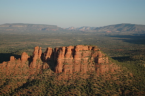
Doe's little brother
by pbaenzig

04/13/00 Summary
07/24/04 Summary


Late in 2006, if I remember correctly, Boynton Pass Road was improved and paved because of a development called "The Aerie." When the road was improved, new trailheads were put in: Fay Canyon trailhead, Doe/Bear Mountain trailhead, and finally a new trailhead designed to access Cockscomb.
remove free decal offer
This new trailhead is past the Doe/Bear Mountain trailhead. You turn left (South) when coming from Sedona onto Aerie Road, a newly paved road leading to the development. After about half a mile, the road splits -- the left branch leading to the gate of the development and the right branch to the new trailhead.

At the far end of the trailhead (already trashed, beer bottles everywhere)you can find faint markings of a new trail. A yet non-existent trail that the Forest Service will build when it gets around to it. In the meantime, the route is marked with red paint and fading yellow ribbons. Enough people have hiked the route so that the non-existing trail is relatively easy to follow.

If you do lose the route, not a major problem. The route essentially leads south, following the terrain contours. Your goal, the north end of Cockscomb is always visible. To the left of you is initially the road leading to the Aerie, then the fence circling the property. As you get closer to the Cockscomb, the Forest Service route merges with existing distinct social trails leading to the start of the ascent. The climb up to the top of the mountain is unchanged and I don't know if the Forest Service ever will develop that part of the hike.

If you hike from the new trailhead to the top of Cockscomb, it's about 3 miles RT and maybe 600 ft CEC. We extended the hike a bit by making a counterclockwise loop around Cockscomb before going up to the top. The little hill almost due SW from the trailhead gives you some great views. The seemingly flat grassland between you and the Cockscomb is anything but flat; it is crisscrossed with deep gullies. As you hike around the Cockscomb you'll come across many stretches of social trail, so the hiking is quite easy.

Overall, a pleasant half-day hike even when looping around.

Gate Policy: If a gate is closed upon arrival, leave it closed after you go through. If it is open, leave it open. Leaving a closed gate open may put cattle in danger. Closing an open gate may cut them off from water. Please be respectful, leave gates as found. The exception is signage on the gate directing you otherwise.

2007-11-30 pbaenzig
  • Cockscomb Area Trails
    guide related
    Cockscomb Area Trails
  • 2021 Verde Valley Trails
    region related
    2021 Verde Valley Trails
  • 2021 Verde Valley Area
    region related
    2021 Verde Valley Area
  • 2021 Sedona Trails Map
    region related
    2021 Sedona Trails Map
Coconino FS Details
The Cockscomb Trail goes south from its trailhead along a jeep road for .3 miles, bends west for .2 miles, then goes southeast along a closed jeep road skirting the face of Doe Mountain. It intersects the Dawa Trail at 1 mile, turns to the southwest, and ends at 1.8 miles near the Cockscomb.

From here, the Cockscomb Trail continues along the old road as the Rupp Trail. It bends to the east and there are nice views all around as it crosses a broad, open expanse before ending at 1.2 miles as it drops down into the Dry Creek drainage and meets the Girdner Trail.

Check out the Official Route and Triplogs.
Leave No Trace and +Add a Triplog after your hike to support this local community.

One-Way Notice
This hike is listed as One-Way.

When hiking several trails on a single "hike", log it with a generic name that describes the hike. Then link the trails traveled, check out the example.
WARNING! Hiking and outdoor related sports can be dangerous. Be responsible and prepare for the trip. Study the area you are entering and plan accordingly. Dress for the current and unexpected weather changes. Take plenty of water. Never go alone. Make an itinerary with your plan(s), route(s), destination(s) and expected return time. Give your itinerary to trusted family and/or friends.

 Permit $$
Red Rock Pass - may or may not be required. Go to Red Rock Pass then check "When is a Red Rock Pass Required?". If you have questions contact the Coconino forest service.


 Directions
or
 Road
Paved - Car Okay

To hike
From the junction of Routes 89A and 179, take 89A west 3.2 miles to Dry Creek Road on the right. Go north 2.9 miles to a "T". Turn left and go 1.6 miles to another "T". Turn left again and go for .6 miles and turn left on FR 9586 (100 feet beyond the turnoff road for Fay Canyon parking on the right). Go 0.1 mile to trailhead parking.

Old Trailhead: The trailhead is off FR 152C, a bumpy gravel road. From the Sedona "Y" ( 179/89A ), follow 89A towards Cottonwood to Dry Creek Road and turn right onto it. Follow the paved road, always turning to the left when you come to one of the two "T" intersections. The last left turn gets you onto FR 152C. Follow it for about half a mile -- you'll see the large, well-marked Fay Canyon trailhead on your right. Just a few yards beyond the Fay turn-off, there is a small, inconspicuous sign "Cockscomb Trail" pointing to a Jeep trail going off to the left. Follow the Jeep trail for a couple of hundred feet (a regular car can handle it if you drive slowly) and you'll come to a large, usually empty parking area.

Directions to Fay: From the 'Y' in Sedona ( 179/89A ) follow 89A 3.1 miles Southwest to Dry Creek Road. Turn Right and go 2.8 miles to Boynton PASS Road. Turn Left and go 2.7 miles, look for a parking area on the Right. There is(perhaps was) a rusty metal sign designating Fay Canyon Trail #53

Old Back Entrance: From the 'Y' in Sedona ( 179/89A ) follow 89A 3.1 miles Southwest to Dry Creek Road. Turn Right and continue 2.9 miles to the three-way intersection with a stop sign. Turn left and follow 0.6 miles. There is a very narrow pullout on the left side to park. No trailhead sign exists. There is a fence marked no motorized vehicles allowed beyond this point. There is a gateless opening in the fence just wide enough to walk through.
 90+° 8am - 6pm kills
helpcorrectionissue

end of page marker