 Route Editor

| Guide | ♦ | 16 Triplogs | 2 Topics |
details | drive | permit | forecast | 🔥 route |
stats |
photos | triplogs | topics | location |
| 5 | 16 | 2 |
Rather B Ridin' by ridebmxdammit   We drove down to Sedona from Corvallis, Oregon, originally intending to hike the Casner Mountain/Taylor Cabin/Sycamore Canyon/Dogie Trail loop, which is about 20 miles from what I've read. However, it didn't entirely turn out that way, mostly because the rangers in the area were incredibly unhelpful and gave us this terrible excuse for a map. The road there was pretty straight forward and not too difficult; I have a Subaru Outback, and it did everything just fine. A small subcompact car might have difficulties, but I think a reasonable driver in a mid- or full-size car could do it. We drove down to Sedona from Corvallis, Oregon, originally intending to hike the Casner Mountain/Taylor Cabin/Sycamore Canyon/Dogie Trail loop, which is about 20 miles from what I've read. However, it didn't entirely turn out that way, mostly because the rangers in the area were incredibly unhelpful and gave us this terrible excuse for a map. The road there was pretty straight forward and not too difficult; I have a Subaru Outback, and it did everything just fine. A small subcompact car might have difficulties, but I think a reasonable driver in a mid- or full-size car could do it.At any rate, the hike itself is pretty strenuous for the first few miles until you top out the mountain. The first mile, maybe a little more, is a moderate incline, but then it gets into some steep switchbacks which take you directly up the side of the mountain. You're hiking along power lines the entire way, which isn't exactly enjoyable; you can hear them buzzing and whatnot, but it's not as bad as I thought it would be.
I've heard the loop is fantastic, and I'd like to go back and complete it one day, but keep in mind that it's one hell of a hike up that freakin' mountain (imagine planning this online thinking it's a 250 ft. climb, driving 25 hours straight to get there, and realizing that the trail goes straight up the side of the mountain...combine that with 60 hours without sleeping, a setting sun, and that was our situation. Joy.)
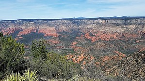
Coconino FS Details Originally built to maintain power lines, Casner Mountain trail offers spectacular views of the Sycamore Canyon and Red Rock/Secret Mountain Wildernesses and the Verde Valley. The trail follows an old jeep road which still provides access to the power lines. The trail begins in high desert vegetation and switchbacks up the side of Casner Mountain. Once on top of the mesa, Pinyon/Juniper with open grasslands are the norm. The ascent is very strenuous and accounts for about 2 miles of the total length. However, once on top the hike is really quite easy to moderate. Take lots of water especially during the Summer months. Wildlife is abundant, particularilly in the winter months. Watch for Elk and Deer. An occassional Bear and even Mountain Lion are spotted. USGS Map: Loy Butte Check out the Official Route and Triplogs. Note This is a moderately difficult hike. Leave No Trace and +Add a Triplog after your hike to support this local community. One-Way Notice This hike is listed as One-Way. When hiking several trails on a single "hike", log it with a generic name that describes the hike. Then link the trails traveled, check out the example. | ||||||||||||||||||||||||||||||||||||||||||||||||||||||||||||||||||||||||||||||||||||||||||||||||||||||||||||||||||||||||||||||||||||||||||||||||||||||||||||||||||||||||||||||||||||||||||||||||||||||||||||


