Route Editor

| Guide | ♦ | 3 Triplogs | 0 Topics |
details | drive | no permit | forecast | map |
stats |
photos | triplogs | topics | location |
| 18 | 3 | 0 |
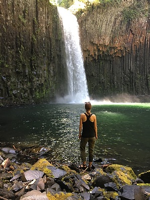
Que Abiqua? by arizona_water Abiqua Falls is an excellent example of basaltic columnar jointing in a huge rock amphitheater, pierced through the center by Abiqua Creek (although it is much more of a river by our HAZ standards). The trail can be a little busy during the summer time, but the area surrounding the falls is large enough to still find some solitude on a hot June afternoon. For a more unique experience, visit in the winter and see the snow crusted basaltic columns contrasting with the frigid rushing waters. Note that crampons or micro-spikes are necessary for winter access. Hike The trail descends quickly from the road to the creek through a forest of mixed hardwoods and pine. Several of the steeper sections have hand-lines installed for assistance. Please respect this area by staying on the designated trails. Erosion has become a serious issue in recent years. Also, stay on the trail to avoid contact with poison oak.
Check out the Triplogs. Leave No Trace and +Add a Triplog after your hike to support this local community. | |||||||||||||||||||||||||||||||||||||||||||||||||||||||||||||||||||||||||||