 Route Editor

| Guide | ♦ | 7 Triplogs | 1 Topic |
details | drive | no permit | forecast | 🔥 route |
stats |
photos | triplogs | topic | location |
| 0 | 7 | 1 |
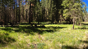
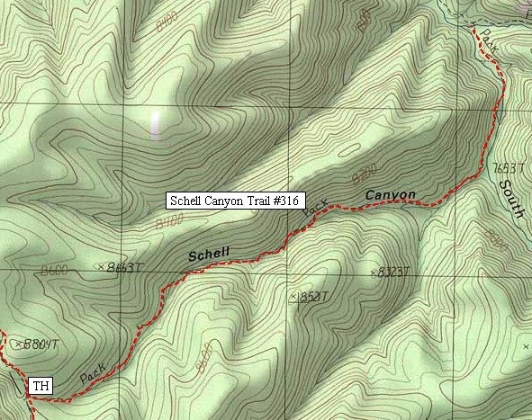
 Apache - Sitgreaves FS Details Apache - Sitgreaves FS DetailsHiking this woodland wilderness trail could be described as a double-barreled experience. First, you'll pass some marvelous scenery along the access route to the trailhead. Then there is the rugged canyon, native trout fishing and picturesque campsites that Schell Canyon Trail itself provides access to in the Bear Wallow Wilderness. To get to the Schell Canyon trailhead you must travel about 3 miles of the Rose Spring Trail #309. That trail follows the dramatic 1500 foot escarpment that forms the southern edge of the Colorado Plateau. The view that this prodigious dropoff offers of the canyons and mountains to the south is one of the most expansive in Arizona. After thrilling you with those magnificent overlooks, the Schell Trail takes you into the heart of the Bear Wallow Wilderness. Within this 11,000 acre area you'll pass through an alpine forest of mixed conifers and aspens as the trail leaves the rim and begins dropping into the Bear Wallow drainage. Tall ponderosa pines and canyon hardwoods shade the South Fork of Bear Wallow Creek, which the trail crisscrosses on its way to the floor of the main canyon. Schell Canyon Trail ends at its junction with Bear Wallow Trail, from which point you can return the way you came (and get another look at those views) or continue down Bear Wallow Creek where a number of streamside campsites provide excellent prospects for an overnight camp or an extended stay. A little-used and unmaintained spur of Schell Canyon Trail leads up the South Fork of Bear Wallow Creek providing opportunities for further exploration in that direction. Even more variations on this same hike are possible if you set up a shuttle or leave a mountain bike at either the Bear Wallow, Reno, or Gobbler trailheads. Then you can return by way of those trails to put together a loop hike of about the same length as a down and back hike along Schell Trail. The ride between Rose Spring trailhead and the Bear Wallow Trail is 10 miles, to Gobbler Point it's 15 miles. Notes: No motorized or mechanized vehicles (including mountain bikes) are permitted in Wilderness. Water runs year-round in both the South Fork and the mainstem of Bear Wallow Creek. This trail was completely reconstructed in 1988 and 89 by two Sierra Club Service Trips and one American Hiking Society volunteer vacation trip. Trail Log: 0.0 Junction with Rose Spring Trail, passes through gate in fence. 0.6 Drops into Schell Canyon Drainage. 2.3 Confluence of Schell Canyon and South Fork of Bear Wallow Creek. 2.8 Junction with Bear Wallow Trail #63 at confluence of north and south forks of Bear Wallow Creek. USGS Maps: Baldy Bill
Check out the Official Route and Triplogs. Leave No Trace and +Add a Triplog after your hike to support this local community. One-Way Notice This hike is listed as One-Way. When hiking several trails on a single "hike", log it with a generic name that describes the hike. Then link the trails traveled, check out the example. | |||||||||||||||||||||||||||||||||||||||||||||||||||||||||||||||||||||||||||||||||||||||||||||||||||||||||||||||||||||||||||||||||||||||||||||||||||||||||||||||||||||||||||||||||||||||||||||||||||||||||||||


