 Route Editor

| Guide | ♦ | 15 Triplogs | 0 Topics |
details | drive | no permit | forecast | 🔥 route |
stats |
photos | triplogs | topics | location |
| 308 | 15 | 0 |
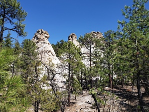
 Bonanza Bill Trail is one of the main trails offering access to the remote eastern reaches of the Blue Primitive Area. In addition to traversing a good portion of this country on its own, Bonanza Bill serves as a connector between several other trails leading into this beautiful, wild country. The trail is named for Bonanza Bill Point, which stands out as one of the more prominent features along the route. This easy-to-follow pathway snakes along a divide that separates the canyons of the Blue and San Francisco Rivers. It sets a course through ponderosa pine stands so open and clear of undergrowth that in places, someone from the brushy forests of the east might swear crews of meticulous gardeners maintain it. Of course, that's not true. Openness is a natural characteristic of a ponderosa pine forest, especially one as dry as this. That openness also makes the surrounding scenery easier to see from the trail. Views include overlooks of Steeple and Tige canyons as well as the larger canyons of the Blue and San Francisco rivers. Bonanza Bill Trail is one of the main trails offering access to the remote eastern reaches of the Blue Primitive Area. In addition to traversing a good portion of this country on its own, Bonanza Bill serves as a connector between several other trails leading into this beautiful, wild country. The trail is named for Bonanza Bill Point, which stands out as one of the more prominent features along the route. This easy-to-follow pathway snakes along a divide that separates the canyons of the Blue and San Francisco Rivers. It sets a course through ponderosa pine stands so open and clear of undergrowth that in places, someone from the brushy forests of the east might swear crews of meticulous gardeners maintain it. Of course, that's not true. Openness is a natural characteristic of a ponderosa pine forest, especially one as dry as this. That openness also makes the surrounding scenery easier to see from the trail. Views include overlooks of Steeple and Tige canyons as well as the larger canyons of the Blue and San Francisco rivers.This trail also roughly follows the boundary between Arizona and New Mexico. In one place, the trail crosses that line for a two-and-a-half-mile visit to Arizona's eastern neighbor. In this vicinity, you'll get some good views of Devil's Monument, a prominent landform in New Mexico. Another interesting area along the trail called Hell's Hole is quite a bit closer to the trailhead. Here dwarfed and deformed ponderosas hold to a precarious existence among exposed layers of white rock.
Notes: Steeple Canyon has pools of water except during the dry seasons of the year. Hinkle Springs, located one-quarter mile down the adjoining Hinkle Trail, is a dependable spring. WS Lake provides water for stock except during the dry season. Keep a clean camp so as not to create problem bears (or trash the area). No mechanized vehicles (including mountain bikes) are permitted within the Primitive Area. Trail Log: 0.0 Trailhead on Pueblo Park Road. 0.9 Junction with Tige Rim Trail #90. Bonanza Bill takes a sharp right at this point. 3.7 Junction with Hinkle Spring Trail, Hell's Hole. 5.9 Junction with Cow Flat Trail, #55. 6.2 Bonanza Bill Point on the right. 8.3 View of Devils Monument to east. 8.5 Trail goes through a gate in New Mexico State Line fence. 11.1 Trail crosses back into Arizona. 12.1 Junction with Franz Spring Trail. Gate Policy: If a gate is closed upon arrival, leave it closed after you go through. If it is open, leave it open. Leaving a closed gate open may put cattle in danger. Closing an open gate may cut them off from water. Please be respectful, leave gates as found. The exception is signage on the gate directing you otherwise. Check out the Official Route and Triplogs. Leave No Trace and +Add a Triplog after your hike to support this local community. One-Way Notice This hike is listed as One-Way. When hiking several trails on a single "hike", log it with a generic name that describes the hike. Then link the trails traveled, check out the example. | |||||||||||||||||||||||||||||||||||||||||||||||||||||||||||||||||||||||||||||||||||||||||||||||||||||||||||||||||||||||||||||||||||||||||||||||||||||||||||||||||||||||||||||||||||||||||||||||||||||||||||||


