Route Editor

| Guide | ♦ | 22 Triplogs | 0 Topics |
details | drive | no permit | forecast | route |
stats |
photos | triplogs | topics | location |
| 35 | 22 | 0 |
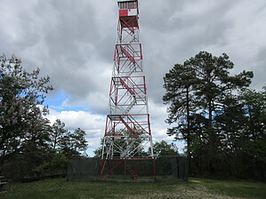
South Jersey's Mount Whitney by Jim  The hike as described here uses the Batona Trail from Carranza Memorial. Because the trail also can be accessed from 532, and the hill can be accessed by many of the dirt roads, various loops and lengths of hikes can be used to reach Apple Pie Hill.
Leaving the campground, the trail is briefly in the trees before returning to the road. You will walk the road for about a half mile and make a left at a T-intersection before crossing a stream over a wooden bridge. The trail will then leave the road and be in dense pitch pine and Atlantic White Cedar Swamps for the next 3 miles. Most of it is monotonous, flat, and almost completely level. There is one small hill you will cross over about 2/3 of the way to Apple Pine Hill. After that point, there is a road crossing and you gain elevation (for South Jersey) to "summit" Apple Pine Hill. If it is still open to the public, you can climb the fire tower and see Philadelphia, Atlantic City, Fort Dix/ McGuire, numerous cranberry bogs, and a lot of flat terrain covered mostly in pitch pine. You can return the way you came, or continue to 532 or points beyond if you parked a car at another Batona Trail road crossing. To do the 8-mile standard hike, return to Carranza. New Jersey and the Pine Barrens region is tick, mosquito, and fly country. In no way, shape or form does any of the area resemble Arizona. Unless extremely cold, spray on some bug spray. I've had ticks on me on a day it was 45 degrees despite it having been in the 20s a few days before. Deer ticks can be hard to spot. They require a keen eye and are the size of a pinhead. Inspect all areas of the body to find them before they dig in. They transmit Lyme Disease, so you'll want to keep them from digging in. They attach to a body when you rub against grass, leaves, or other vegetation. They usually are found low but can be higher up, too. Inspect the scalp and areas of the body where clothing is tight, as they like the hard-to-reach places. Mosquitoes are pretty bad in the warm months, but mostly at night. Unless you visit in a drought, they will be really bad compared to our dry western standards, especially in the wet times. Biting flies are also fierce, and they haunt the day. Bug spray's powers are useless against them, as is running away as that seems to attract them. I remember them chasing my car to try to bite it. Baffling! Their bite is horrendous. My hand once swelled up to nearly twice its size after being bitten by one. It went down quickly but was nasty for a few hours. At this point, I wonder why I ever liked this area, and you might be thinking it is not worth even thinking about. It isn't all that bad and can be pleasant, you just have to know the area and what you are up against. Blueberries can be gathered in summer. Amphibians and birds are vocal in spring and early summer, as are cicadas. In late summer and early fall, Katydids and crickets make for a pleasant evening chorus. Views are still pretty good, and if not too humid and a dense layer of filth doesn't hide the sun, the sunsets from the tower are usually really pleasant. It is no Piestewa Peak or Mount Elden, but it is all they have back there. September 2016 The fire tower is fenced off due to vandalism. Unless manned, the tower is closed to the public so sunsets are no longer an option. Check out the Official Route and Triplogs. Leave No Trace and +Add a Triplog after your hike to support this local community. | ||||||||||||||||||||||||||||||||||||||||||||||||||||||||||||||||||||||||||||||||||||||||||||