 Route Editor

| Guide | ♦ | 12 Triplogs | 0 Topics |
details | drive | no permit | forecast | 🔥 route |
stats |
photos | triplogs | topics | location |
| 68 | 12 | 0 |
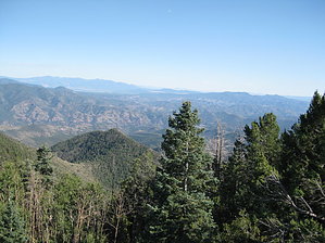
between violet and green by HAZ_Hikebot  Where there's a lookout, you know the views have to be good. Unsurpassed panoramas, a touch of wild history, and access into one of the Blue Area's largest side canyons are some of the attractions offered by this steep, high country trail. The trail begins about 0.6 miles below the lookout, but you'll want to hike up to the summit of Blue Peak to enjoy the panorama. The Blue Range and Blue River Canyon, Eagle Creek, Mount Graham, and the Pinalenos to the south, the Mogollon Range in New Mexico, and the canyon of the San Francisco River are just a few of the sights you can see from this vantage point. When you hike this trail, be sure to bring along a map for the Gila National Forest in New Mexico as well as an Apache-Sitgreaves map to help you identify all the landmarks. If you can get a map of southwest New Mexico and southeast Arizona, you might be better off. The views are that big. Where there's a lookout, you know the views have to be good. Unsurpassed panoramas, a touch of wild history, and access into one of the Blue Area's largest side canyons are some of the attractions offered by this steep, high country trail. The trail begins about 0.6 miles below the lookout, but you'll want to hike up to the summit of Blue Peak to enjoy the panorama. The Blue Range and Blue River Canyon, Eagle Creek, Mount Graham, and the Pinalenos to the south, the Mogollon Range in New Mexico, and the canyon of the San Francisco River are just a few of the sights you can see from this vantage point. When you hike this trail, be sure to bring along a map for the Gila National Forest in New Mexico as well as an Apache-Sitgreaves map to help you identify all the landmarks. If you can get a map of southwest New Mexico and southeast Arizona, you might be better off. The views are that big.When you can tear yourself away from the views at the trailhead and start back down the trail, you'll find you're in for a steep trip down a switchback staircase. The first stop along the descent to KP Canyon is an old cabin once used as a home by the lookout. It was also once used as a hideout by a bank robber. The fellow held up a bank in McNary in 1921 reportedly to secure money the bank refused to loan him to bring his mother to the US from Germany. Neither his altruistic intentions nor the fact that he was about to give himself up was enough to avert the tragic course of events the robbery set in motion. One member of the posse that came to apprehend the unfortunate soul shot him down as he stepped out of the cabin with his hands up. If you're ever on Forest Road 249 at the west end of Williams Valley, you might notice his crude grave marker. The posse buried him there on the trip back to town.
Notes: No mechanized vehicles (including mountain bikes) permitted in Primitive Area. Trail Log: 0.0 Trailhead at McKittrick Trail #72. 0.9 Junction with Blue Lookout Trail #321, site of an old cabin. 2.9 Junction with KP Trail #70. USGS Maps: Strayhorse Check out the Official Route and Triplogs. Leave No Trace and +Add a Triplog after your hike to support this local community. One-Way Notice This hike is listed as One-Way. When hiking several trails on a single "hike", log it with a generic name that describes the hike. Then link the trails traveled, check out the example. | ||||||||||||||||||||||||||||||||||||||||||||||||||||||||||||||||||||||||||||||||||||||||||||||||||||||||


