 Route Editor

| Guide | ♦ | 28 Triplogs | 1 Topic |
details | drive | no permit | forecast | 🔥 route |
stats |
photos | triplogs | topic | location |
| 171 | 28 | 1 |
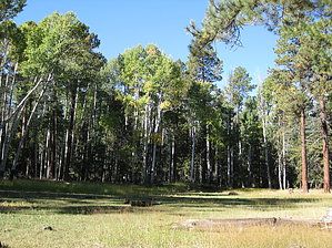
It's all yellow by HAZ_Hikebot  The Northwest portion of the Blue Range Primitive Area where this trail is located has been severely affected by the Wallow Fire of June 2011. The area is currently open to public use and entry - HOWEVER, trails may not have been recently assessed or maintained for hazards associated with the fire, so plan your trip accordingly. The Northwest portion of the Blue Range Primitive Area where this trail is located has been severely affected by the Wallow Fire of June 2011. The area is currently open to public use and entry - HOWEVER, trails may not have been recently assessed or maintained for hazards associated with the fire, so plan your trip accordingly.Please remember that any area affected by the wildfire can be prone to hazards such as falling trees, flooding, and burned-out stump holes. The environment you are entering is highly susceptible to rainstorms and wind events. Any time you enter the forest, you should be aware of your environment and changing weather conditions. You are responsible for your own safety! Always look up, look down, and look all around. Grant Creek Trail #75 is a major travel route between the rim and the floor of Blue River Canyon. Along the way, it offers a good sampling of some of the best the Blue country has to offer, from lush alpine forests to deep red rock canyons.
Grant Creek Trail is a major travel route between the rim and the floor of Blue River Canyon. Along the way, it offers a good sampling of some of the best the Blue country has to offer, from lush alpine forests to deep red rock canyons. Trail access (via Foote Creek Trail #76 is located close to Hannagan Campground, which accounts that this is one of the most well-used trails in the District). But don't let that deter you. No trail on the Alpine District is crowded. Grant Creek Trail wanders among cool forests for its first few miles before beginning to seriously slope toward the canyon. The upland part of the trail offers good opportunities to see wildlife as you walk quietly through the trees. Some hike this section of the trail and return via the more rugged Grant Cabin and Upper Grant Creek Trails to put together a day hike entirely within the cool confines of the forest. As the gradient steepens beyond Paradise Park, the forest becomes more open, and views broaden. Panoramas of Blue River Canyon and the surrounding mountains from the horizon. The views of the mountains across the Blue and overlooks of the red rock formations along Grant Creek continue to improve as the trail follows a sloping ridge into the canyon. Long-distance views then shrink as the horizon narrows, but you won't miss them as your attention turns to the natural sculptures of colorful red rocks that form the canyon walls here. These rugged formations set a photogenic contrast with the bright green of the box elders, narrow leaf cottonwoods, and Arizona sycamores that thrive in the moist, sheltered habitat. Also nestled between these walls are the pools and riffles of Grant Creek, which flows year-round. After providing a welcome opportunity to cool off, the trail stays with Grant Creek as the canyon broadens and continues toward the Blue. Notes: No mechanized vehicles (including mountain bikes) permitted in Primitive Area. White Oak Spring and Grant Creek provide reliable sources of flowing water. Trail Log: 0.0 Trail terminus. Junction with Foote Creek Trail #76 at P-Bar Lake. Grant Creek Trail forks to the right, Foote Creek Trail forks to the left. 1.1 Trail switchback. 1.5 Junction with Grant Cabin Trail #306. There is a gate at this point. 2.7 Junction with Paradise Trail #74. 4.1 Spur trail to the left to White Oak Spring. Grant Creek Trail continues straight and begins descending an arid ridge. 5.9 Trail crosses Grant Creek. 8.8 Gate near moth of Grant Creek. 9.1 Trailhead adjacent to Blue River Road, Forest Road 281. USGS Maps: Hannagan Meadow, Beaverhead, Bear Mountain. Gate Policy: If a gate is closed upon arrival, leave it closed after you go through. If it is open, leave it open. Leaving a closed gate open may put cattle in danger. Closing an open gate may cut them off from water. Please be respectful, leave gates as found. The exception is signage on the gate directing you otherwise. Check out the Official Route and Triplogs. Note This is a moderately difficult hike. Leave No Trace and +Add a Triplog after your hike to support this local community. One-Way Notice This hike is listed as One-Way. When hiking several trails on a single "hike", log it with a generic name that describes the hike. Then link the trails traveled, check out the example. | ||||||||||||||||||||||||||||||||||||||||||||||||||||||||||||||||||||||||||||||||||||||||||||||||||||||||||||||||||||||||||||||||||||||||||||||||||||||||||||||||||||||||||||||||||||||||||||||||||||||||||||||||||||||||||||||


