 Route Editor

| Guide | ♦ | 58 Triplogs | 2 Topics |
details | drive | no permit | forecast | 🔥 route |
stats |
photos | triplogs | topics | location |
| 308 | 58 | 2 |
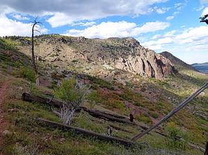
Flagstaff's Most Geologically Diverse Hike! by Jim  The Heart Trail #103 is not hiked all that often when compared to the Elden Lookout Trail #4. The area it goes through was severely burned in the 1977 Radio Fire, and it is slowly recovering. However, in the same way that the Radio Fire was good for revealing the view of Flagstaff and the surrounding area from the summit of Mount Elden, so too was that fire good for exposing the geology of the Heart Trail and the east face of Mount Elden. The Heart Trail #103 is not hiked all that often when compared to the Elden Lookout Trail #4. The area it goes through was severely burned in the 1977 Radio Fire, and it is slowly recovering. However, in the same way that the Radio Fire was good for revealing the view of Flagstaff and the surrounding area from the summit of Mount Elden, so too was that fire good for exposing the geology of the Heart Trail and the east face of Mount Elden.Mount Elden is a massive Dacite lava dome. Most people who are familiar with the Elden Lookout Trail #4 or the Fat Man's Loop Trail #25 know about Elden's Dacite. They have probably hiked the trails while looking up at the massive flows of rock that came pouring down from some lava vent thousands of feet above the base of the 9,300' mountain that marks the eastern skyline of Flagstaff. What they may not know is that in order for this lava to come to the surface, it had to come up through many thousands of feet of sedimentary rock that composes the Colorado Plateau. Think of the view at the Grand Canyon or in Sedona, and you'll know what the lava came up through. Now, I'm no geology expert, but I did take a 100 level geology course in the fall of 2000, and I have stayed in enough Holiday Inn Expresses to know that when this lava pushed up through the crust, it forced some of the sedimentary rock up as it moved through the layers. These layers are present on the east face of Mount Elden as discontinuous sedimentary layers that are exposed and available for your viewing pleasure.
The Heart Trail begins at a junction with the Sandy Seep Trail, and the easiest way to reach the Heart Trail is via the Sandy Seep Trail. On the east side of the Sandy Seep/ Heart Trail junction, there is a small juniper and oak-covered hill that appears to be just another lava dome or cinder cone, which is so common in the area east of Flagstaff. However, this is a hill of white Coconino Sandstone that has been pushed up and had its limestone cap eroded away. When you first set out on the Heart Trail, you'll be on the typical weathered Dacite gravels, sands, and silts that surround Mount Elden. This gives way to red sandstone, much as you would see in Sedona. In some places, the sandstone is intact and exposed well enough at the surface to see the sedimentary layers. You will alternate with red sandstone and weathered Dacite soils for a while before you begin to climb up switchbacks. Now a note on the vegetation. As you hike the trail uphill, you'll lose the few ponderosa pines that have managed to regenerate in this area following the Radio fire. The lower area is coming back in almost pure Gambel Oak. These trees are still rather small. In the future, there may be a closed canopy of oaks over parts of the trail. Far in the future. Further up the trail, you pick up aspens, Douglas firs, and white pines. It will be some time here as well, but recovery is proceeding along the Heart Trail. Compared to the windswept summit of Elden, the area along the Heart Trail actually looks rather good. This area benefits from being close to the seed sources on top of Little Elden and the area near Sunset Park. Climbing the switchbacks, you can get a view of the volcanic cliffs that are the south face of Little Elden, the white rock underneath them, and the deep red rock under the white layer. The lower 1/3 to 1/2 of the trail continues on in the red sandstone layer. At some point in the middle of the hike, you will encounter layers of white rock mingling in with the red rock. Most of the white rock is limestone. Some is Coconino Sandstone; the same sandstone that we saw at the start of the trail. You will have to go slowly to watch for the Coconino Sandstone up here. You can tell it by its white color, its gritty sandy texture, and the noticeable lack of marine fossils. If you discover the Coconino Sandstone that I saw, you will pass through more red sandstone before getting to the layers of white limestone. Coconino Sandstone is usually above the red sandstone, not mixed with it as it occurs on Elden. You then hike through more red sandstone before reaching limestone. You can see fossils within the lower layers of the white Kaibab Limestone that is on the east face of Elden. Towards the top, the limestone looks more like volcanic rock or metamorphic dolomite. It appears to have no fossils in it. It may be Dolomite, but I doubt that the white rock near the top is volcanic. It contrasts sharply with the rest of the volcanic rock on Elden, and it has no noticeable point of origin, unlike the rest of Elden's flows. Passing above the limestone, you emerge onto the Dacite that is Mount Elden and the upper terminus of the Heart Trail. You can connect to various other trails to do a loop or descend the way you came. I have also hiked the nearby Little Bear Trail, and unless you want to go to the summit of Elden, it may be worth doing a Heart-Little Bear-Little Elden Trail Loop. I recommend this because, on the Little Bear Trail, you can also find some broken limestone pieces on the trail. This area may be reasonably similar to how the Heart Trail looked before June of 1977. So, thanks to the miracle of escaped campfires on windy June Days, we have the pleasure of observing the exposed sediments without the burden of thick vegetation.
Check out the Official Route and Triplogs. Leave No Trace and +Add a Triplog after your hike to support this local community. One-Way Notice This hike is listed as One-Way. When hiking several trails on a single "hike", log it with a generic name that describes the hike. Then link the trails traveled, check out the example. | ||||||||||||||||||||||||||||||||||||||||||||||||||||||||||||||||||||||||||||||||||||||||||||||||||||||||||||||||||||||||||||||||||||||||||||||||||||||||||||||||||||||||||||||||||||||||||||||||||||||||||


