This trail leads to one of the best views I've run into in Coconino National Forest, yet relatively few people seem to know it exists and fewer still think it's worth checking out. The Forest Service lists the use of this trail as 'moderate' but I have made this climb several times at different times of year and day and I have yet to see a single soul on the trail.
To reach the trailhead from Flagstaff, go North on US 180 for about thirty miles then turn left on FR 191. Follow 191 for two miles and you will come to the trailhead parking on your right. Note that FR 191 has a few spots where water collects that may render it impassable to cars at times; high clearance vehicles should have no problem. This sounds easy enough but finding the turnoff is a challenge if you are coming from Flagstaff as you cannot see the turn until you are almost upon it and there is no sign whatsoever. The easiest way to find it is to note your mileage as you pass the AZ Snowbowl turnoff; from the intersection of Snowbowl Rd. and 180 it is exactly twenty miles ( dlippy1 clarifies it's 18.9 miles ) to the FR 191 turnoff. If you reach the Red Mountain trailhead turn-off, you have gone several miles too far. It's much easier to find the turn when you're heading South as there is a sign and you can see the road from a much greater distance.
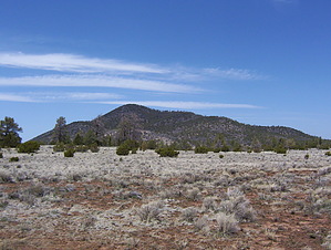
From the trailhead, you will first skirt around a small drainage before beginning a series of gentle switchbacks that take you about halfway up the mountain. After that, the trail swings all the way around a smaller East summit crosses the saddle between this and the real summit, and then makes a big clockwise spiral up the rest of the way to the top where you will find outcroppings of the slate from which the mountain gets its name. The summit is mostly clear of the Ponderosa pines that make up the bulk of the vegetation along the trail allowing for wide, unobstructed views of the San Francisco Peaks, Kendrick Mountain, the Painted Desert, and everything North to the Grand Canyon which is plainly visible near the horizon. On a clear day, you can see as far as Navajo Mountain in Utah. It is also an excellent place to watch the sunset and at night the clear dark skies allow you to see more stars than you ever thought existed. The trail is very easy; wide and smooth, it is possessed of a shallow, even grade throughout. As for route finding, you would have to try to get lost from this trail. Along the length of the trail are interpretive signs outlining some of the plant species found on the mountain. While I'll grant that this trail is not nearly as challenging or spectacular as Mt. Humphreys, it is still one of my favorites for great views without huge crowds--a rare combination for a location as easily reached as this. This hike makes a great one-two punch with the nearby Red Mountain Trail or as a stop-off on the way to or from the Grand Canyon. It might not be worth a special trip by itself, but there's a good enough payoff for very little time and effort to more than justify stopping if you're passing by.
Coconino FS Details Though this trail has a humble beginning at an old roadblock, it quickly reveals itself to be one of the Coconino National Forest's premier day hikes. Actually an old jeep track, now used solely as a foot trail, this 2.4 mile climb is a gradual but steady ascent along a wide gravel track to some of the best views on the forest. Interpretive signs along the way add a bit of educational interest by naming trailside species of trees and shrubs.
Near the top of the climb, the path spirals up the mountain's narrow summit like a stripe up a barber pole. The effect is as if you were riding past some of the Forest's most spectacular scenery on a huge lazy Susan. The San Francisco Peaks, Kendrick Mountain, Red Mountain, the Grand Canyon, Painted Desert, you can see them all, just by turning your head, from the top of Slate Mountain.
WARNING! Hiking and outdoor related sports can be dangerous. Be responsible and prepare for the trip. Study the area you are entering and plan accordingly. Dress for the current and unexpected weather changes. Take plenty of water. Never go alone. Make an itinerary with your plan(s), route(s), destination(s) and expected return time. Give your itinerary to trusted family and/or friends.
Permit $$
None
Directions
Road
FR / Dirt Road / Gravel - Car Okay
To hike Location: 37 miles (about 45 minutes) north of Flagstaff between the Grand Canyon and the San Francisco Peaks.
Access: Drive 35 miles north of Flagstaff on US 180 to FR 191. Turn west 2 miles to the trailhead on the right side of the road. US 180 is paved. FR 191 is graveled and suitable for passenger cars in most weather.
Author Writes:
From Flagstaff take US 180 North for about thirty miles and turn left onto FR 191. Follow 191 for two miles and the trailhead parking will be on your right. NOTE: the FR 191 turnoff is hard to find when heading North, see the description for more details. ( between mile marker 242 and 243 and features a large sign )
 Route Editor

 This trail leads to one of the best views I've run into in Coconino National Forest, yet relatively few people seem to know it exists and fewer still think it's worth checking out. The Forest Service lists the use of this trail as 'moderate' but I have made this climb several times at different times of year and day and I have yet to see a single soul on the trail.