Route Editor

| Guide | ♦ | 7 Triplogs | 0 Topics |
details | drive | no permit | forecast | route |
stats |
photos | triplogs | topics | location |
| 38 | 7 | 0 |
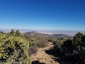
 History HistoryNamed for Cherum, a Hualapai chief, and a full-day battle that took place there in January of 1868 during the Hualapai War from 1866 to 1870. Estimated that 1/3 of the Hualapai people died during the conflict through violence or whooping cough. - @DennisWilliams Hike The route climbs steadily to gain about 700 feet of elevation over the first two miles, passing through patches of pinyon pine woodland and Arizona chaparral bush. You will be high on the crest of the Cerbat Mountains at about the two-mile mark, with spectacular panoramic views of the Black Mountains to the west and the Music Mountains to the east. Hikers continuing from this point will find that the trail ties into a little-used jeep road about one-quarter mile later. Following the jeep road for a short distance, you will be just below Cherum Peak summit. The trail once again becomes a single track at this point, leading to the summit. Horses and mountain bikes are not recommended on the last 1/4 mile of the trail leading to the peak.
Check out the Official Route and Triplogs. Leave No Trace and +Add a Triplog after your hike to support this local community. | |||||||||||||||||||||||||||||||||||||||||||||||||||||||||||||||||||||||||||||||