 Route Editor

| Guide | ♦ | 6 Triplogs | 0 Topics |
details | drive | no permit | forecast | route |
stats |
photos | triplogs | topics | location |
| 34 | 6 | 0 |
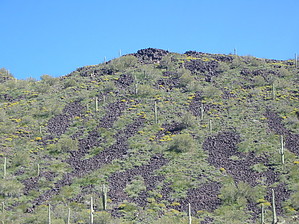
Better than Havasu! (Opinions Vary) by HAZ_Hikebot  Lava Flow Trail, in the 34,400-acre Table Top Wilderness, offers a hiking opportunity of light to moderate difficulty in a varied and dramatic Sonoran Desert landscape. Three trailheads are linked by a relatively level 7 1/4-mile trail. From south to north, the trail meanders through dense forests of saguaro, paloverde, ironwood, and cholla; skirts the jumbled basaltic slopes of Black Mountain; traverses an extensive creosote-bush flat, and crosses several large washes. Lava Flow Trail provides sweeping views of Vekol Valley and the Sand Tank Mountains to the West. Flat-topped Table Top Mountain - the highest point in the Table Top Wilderness - looms to the east. Lava Flow Trail, in the 34,400-acre Table Top Wilderness, offers a hiking opportunity of light to moderate difficulty in a varied and dramatic Sonoran Desert landscape. Three trailheads are linked by a relatively level 7 1/4-mile trail. From south to north, the trail meanders through dense forests of saguaro, paloverde, ironwood, and cholla; skirts the jumbled basaltic slopes of Black Mountain; traverses an extensive creosote-bush flat, and crosses several large washes. Lava Flow Trail provides sweeping views of Vekol Valley and the Sand Tank Mountains to the West. Flat-topped Table Top Mountain - the highest point in the Table Top Wilderness - looms to the east.FACILITIES: No facilities are provided at the three Lava Flow Trail trailheads.
NOTES • Lava Flow Trail receives very little use. Always tell a friend or relative where you are going and when you plan to return. • Drinking water is not provided at Table Top Trail, so bring plenty. • Vekol Valley is prone to heavy rains and flash floods. Do not attempt to cross flooded washes. • You may encounter rattlesnakes or other poisonous creatures; watch for them and be careful where you put your hands and feet. Do not harass reptiles - most bites result from people playing with, collecting, or attempting to kill them. • Fires are not allowed in the Table Top Wilderness. • Pets must be leashed.  Check out the Official Route and Triplogs. Leave No Trace and +Add a Triplog after your hike to support this local community. One-Way Notice This hike is listed as One-Way. When hiking several trails on a single "hike", log it with a generic name that describes the hike. Then link the trails traveled, check out the example. | ||||||||||||||||||||||||||||||||||||||||||||||||||||||||||||||||||||||||||||||||||||||


