 Route Editor

| Guide | ♦ | 7 Triplogs | 0 Topics |
details | drive | no permit | forecast | map |
stats |
photos | triplogs | topics | location |
| 0 | 7 | 0 |
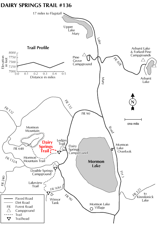
 This short, self-guided nature trail is most popular with campers at Dairy Springs Campground. The trail winds through a forest of ponderosa pines interspersed with white firs and junipers that spreads across the lower slopes of 8,449 foot Mormon Mountain. Interpretive stations along the route enable hikers equipped with trail guides to learn more about the complex ecosystem that makes up the northern Arizona forest. They'll help you learn the names of all those trees, too. Trail guides are available, in season, from the campground host. This short, self-guided nature trail is most popular with campers at Dairy Springs Campground. The trail winds through a forest of ponderosa pines interspersed with white firs and junipers that spreads across the lower slopes of 8,449 foot Mormon Mountain. Interpretive stations along the route enable hikers equipped with trail guides to learn more about the complex ecosystem that makes up the northern Arizona forest. They'll help you learn the names of all those trees, too. Trail guides are available, in season, from the campground host.Dairy Springs Nature Trail is actually a spur off the longer Mormon Mountain Trail which leads to the top of the smallest of the major volcanoes in the San Francisco Peaks volcanic area.
Check out the Triplogs. Leave No Trace and +Add a Triplog after your hike to support this local community. One-Way Notice This hike is listed as One-Way. When hiking several trails on a single "hike", log it with a generic name that describes the hike. Then link the trails traveled, check out the example. | ||||||||||||||||||||||||||||||||||||||||||||||||||||||||||||||||||||||||||||||


