Route Editor

| Guide | ♦ | 45 Triplogs | 1 Topic |
details | drive | no permit | forecast | route |
stats |
photos | triplogs | topic | location |
| 322 | 45 | 1 |
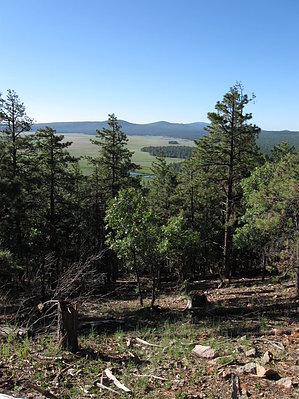
Nice and Easy by Jim  Overview OverviewMormon Mt is one of the lesser-used trails in the heavily used Coconino National Forest. It's easy to find and has paved surfaces nearly to the trailhead. The trail is pleasant, and the mountain enjoyable. Views are somewhat lacking. Mormon Mountain Trail #58 is a nice quiet hike with a low likelihood of seeing other people, except when the nearby campgrounds are under heavy use. Judging from the sign-in sheet at the trailhead, which had dates from September to early December, there is light usage of the trail. Less than three single-sided sheets were filled out. Other area hikes like Elden go through a sheet every day or so during the same period.
The trail itself starts at 7,200' and climbs 3 miles to the top of Mormon Mt, which is somewhere around 8,449'. The trail may not reach that "summit," but a short side trip to some of the higher ridges on the side of the trail at the top probably gets you to that point. Trail quality is good and very gentle. Some parts are a little rocky, but this is nothing a seasoned hiker couldn't handle. There is only one switchback on the trail. If you are like me, you won't notice the climb for most of the hike. Wildlife is abundant in the area, but larger animals are most likely nocturnal. I hiked a few days after a light snow event and was the first person back on the trail. I saw my tracks and many other animal tracks as well-elk, mule deer, bear, mt lion, turkey, fox, small feline, rodents, and other small mammalian tracks. Birds were relatively abundant for early winter as well. Chickadees and nuthatches were everywhere, and because of the abundance of snags, woodpeckers were plentiful and quite busy. The area has numerous stumps with old fire scars at their bases; evidence of past fire activity. However, fire has been absent from most of the mountain for a very long time. Consequently, white fir (abies concolor) is relatively abundant. The large ones are impressive, but there are numerous thickets of fir reproduction. Some of these areas block the view at the top of the mountain. You can't see any peaks from the trail. The best views are through the trees at elevations under 8,000' and of Mormon Lake. It's not bad, but I like to look at the volcanic peaks up towards Flagstaff. Just after the trail meets FR 648, I went off to the northwest and found a small opening through which I could see Kendrick and the San Fransisco Peaks complex. Views are lacking, but you can find them if you look hard enough. The hike is a gentle one and quite pleasant. The trail is good, and I would recommend it to anyone. Unless it happens to be a busy summer weekend, I would think you could be the only one out there. So, enjoy! Coconino FS Details This trail to the top of 8,449 foot Mormon Mountain climbs gradually through a forest of ponderosa pine, mixed conifers, and aspen. At a number of places along the route openings in the forest canopy provide long distance views of Mormon Lake and the grassy flats and forest-covered hills that surround it. The trail begins at the rear of the group-camp area of Dairy Springs Campground, which is located just west of the road that borders Mormon Lake s eastern shore. For a short distance after leaving the trailhead, Mormon Mountain Trail shares the path with the self-guided nature trail that skirts the campground. The mountain trail then branches off on its own to complete the 1,500 foot climb. As the trail nears the top of Mormon Mountain it joins a primitive road (FR 648) which leads to the summit and good views of Mormon Lake and the San Francisco Peaks.
Check out the Official Route and Triplogs. Leave No Trace and +Add a Triplog after your hike to support this local community. | |||||||||||||||||||||||||||||||||||||||||||||||||||||||||||||||||||||||||||||||||||||||||||||||||||||||||||||||||||||||||||||||||||||||||||||||||||||||||||||||||||||||||||||||||||||||||||||||