username
X
password
register
for free!
help
 

Walker Basin Trail #81 - Camp Verde, AZ

Guide 6 Triplogs  0 Topics
  2.2 of 5  
Fav
Wish
2
details
drive
no permit
forecast
route  
stats
photos
triplogs
topics
location
44 6 0
Statistics
tap row or icons for details
Difficulty 2.5 of 5
Distance One Way 6.9 miles
Trailhead Elevation 4,000 feet
Elevation Gain 1,783 feet
Accumulated Gain 2,130 feet
Avg Time One Way 3-4 hours
Kokopelli Seeds 14
 Backpack Yes & Connecting
feature photo
Photos Viewed All MineFollowing
28  2024-12-15 mt98dew
7  2019-05-23 dolomite792
9  2011-09-17 ruielu
Author
author avatar Guides 16,843
Routes 17,472
Photos 24
Trips 1 map ( 6 miles )
Age 28 Male Gender
Location HAZ, TrailDEX
Associated Areas
list map done
Camp Verde Region
Historical Weather
Trailhead Forecast
Radar Map
Expand Map
Preferred Apr, Mar, Nov, Oct
Seasons   Early Spring to Late Autumn
Sun  6:03am - 6:48pm
Official Route
 
0 Alternative


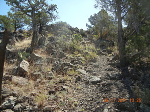
Take a Walk on the Basin Side
by HAZ_Hikebot

There's a classic western landscape waiting for you along this trail, with broad panoramas on the horizon and a collection of bluff-rimmed basins, basalt buttes, rocky canyons, and lots of cactus-covered desert closer at hand.


Once used mainly to move livestock between seasonal pastures, the Walker Basin Trail now provides forest visitors with an access route into this land of big skies and expansive views. A short distance from the upper trailhead, the panorama unfolds like a gigantic mural painted on the sky. Prominent on the horizon are the San Francisco Peaks, with the northern Arizona rim country stretching out at their feet. Wet Beaver Creek and Woods Canyons are obvious as jagged rifts in this otherwise flat plateau. Off to the west, the sculptured buttes and pinnacles of Sedona Red Rock Country are plainly visible.
remove free decal offer
The route leads from one forest road to another as it drops off the southern edge of the Colorado Plateau. For the best views, you'll want to start from the upper end and walk downhill. That way you'll always be facing the broadest overlooks. From the trailhead, the route follows a rough jeep track through an old juniper push. Here the trees have been removed to promote grass growth for grazing. The trail quickly enters the trees, however, and wanders into Walker Basin, a forested depression rimmed by volcanic cliffs. The trail then gradually descends from the basin into a desert canyonscape of red rock cliffs, volcanic buttes, and prickly pear cactus.

2008-04-21 HAZ_Hikebot
  • Walker Basin Trail #81 Map
    guide related
    Walker Basin Trail #81 Map


Check out the Official Route and Triplogs.
Leave No Trace and +Add a Triplog after your hike to support this local community.

One-Way Notice
This hike is listed as One-Way.

When hiking several trails on a single "hike", log it with a generic name that describes the hike. Then link the trails traveled, check out the example.
WARNING! Hiking and outdoor related sports can be dangerous. Be responsible and prepare for the trip. Study the area you are entering and plan accordingly. Dress for the current and unexpected weather changes. Take plenty of water. Never go alone. Make an itinerary with your plan(s), route(s), destination(s) and expected return time. Give your itinerary to trusted family and/or friends.

 Permit $$
None


 Directions
or
 Road
FR / Dirt Road / Gravel - Car Okay

To hike
Location: 53 miles south of Flagstaff on paved and graveled forest roads in picturesque Desert Canyon Country.

Access-Upper Trailhead: Drive 40 miles south of Flagstaff on Interstate 17 to the AZ 179 exit and turn east under the freeway. Drive about 9 miles on FR 618 to FR 214. Turn east and drive 7.3 miles to the trailhead where a jeep track turns off to the left.

Access-Lower Trailhead: Drive 40 miles south of Flagstaff on Interstate 17 to the AZ 179 exit and turn east under the freeway. Drive 4.5 miles on FR 618 to FR 9201C. If you don't have a high clearance vehicle you will want to park here and walk the last mile to the trailhead.
 90+° 8am - 6pm kills
helpcorrectionissue

end of page marker