Route Editor

| Guide | ♦ | 2 Triplogs | 0 Topics |
details | drive | no permit | forecast | route |
stats |
photos | triplogs | topics | location |
| 32 | 2 | 0 |
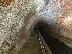
There is light at the end of it by kingsnake To avoid six miles of Potomac River bends and steep cliffs, engineers considered three alternatives: 1) follow a hollow southwest (too far from the river), 2) navigate the river itself (a "slackwater"), or 3) bore a tunnel south. They chose Door #3. Construction began in 1836. There were many delays due to landslides, as the tunnel cross-sected the soft shale vein. More delays were caused by unrest due to slow pay and disputes between the Irish and German laborers. The tunnel was finally completed in 1850, making the C&O Canal fully navigable 184.5 miles from Cumberland to Washington, D.C.
On sat view, you may see vehicles parked at the tunnel's south entrance. Those are NPS. You have to park at the campground at canal MP 156.3 (see driving directions), which has 10 numbered spots, each with a picnic table, grill, and fire pit. There are informational signs by the multiple frequently cleaned portapotties. (One is handicap accessible.) There is a well hand pump. Camping is $20 / night and reservations are required. Personally, I’d camp for free at Purslane Run (MP 156.9). Campground parking is at least free. Bring a flashlight! Synopsis Though essentially level, people with balance problems may have issues due to the lumpy & often puddled trail surface in the 3,118 ft. / 0.6 mi. tunnel. It is a 0.5 mi. stroll from the campground to the south entrance, which has multiple info signs, two picnic tables, a well hand pump, a portapotty, and a map board. Climbing the stone stairs on either side of either entrance is verboten. Bikes must be walked through the tunnel, and along the boardwalk at the north end of Tunnel Hollow. Around MP 156.0, there is a canal crossing and trail, that are an alternate route over the ridge. At the tunnel's south entrance, is Tunnel Hill Trail, the official "detour" over the ridge. The two connect halfway up. Tunnel Hill Trail is 1.4 mi., 360 AEG, one way. Campground to the north end is 1.1 miles, one-way. To the end of the boardwalk, 1.3 miles. To Tunnel Hill Trail's north end, 1.4 miles. To Lock 66, 1.6 miles. Check out the Official Route and Triplogs. Leave No Trace and +Add a Triplog after your hike to support this local community. | |||||||||||||||||||||||||||||||||||||||||||||||||||||||||||||||||||||||||||