For much of its length the Houston Brothers Trail wanders along the bottom of Houston Draw, a picturesque little valley through which a spring-fed perennial stream flows. The scenery here is mostly pastoral with a few photogenic rock outcrops and aspen groves to remind you that you're in rim country.
This trail served a number of purposes during a heyday that stretched over most of the first half of this century. The Houston brothers were ranchers who used it for moving livestock from one part of the range to another. The Forest Service used the trail to move fire guards into isolated forest cabins where they were on twenty-four hour duty during times of high fire danger. Evidence of both of these pages out of the trail's history is visible at a number of locations, including a cabin site which Gifford Pinchot, father of the U. S. Forest Service singled out for its peaceful beauty. Today this trail is part of the Cabin Loop trail system, which provides an opportunity for Forest visitors to relive an aspect of Forest history while they enjoy the area's natural beauty. Map
When hiking several trails on a single "hike", log it with a generic name that describes the hike. Then link the trails traveled, check out the example.
WARNING! Hiking and outdoor related sports can be dangerous. Be responsible and prepare for the trip. Study the area you are entering and plan accordingly. Dress for the current and unexpected weather changes. Take plenty of water. Never go alone. Make an itinerary with your plan(s), route(s), destination(s) and expected return time. Give your itinerary to trusted family and/or friends.
Permit $$
None
Directions
Road
FR / Dirt Road / Gravel - Car Okay
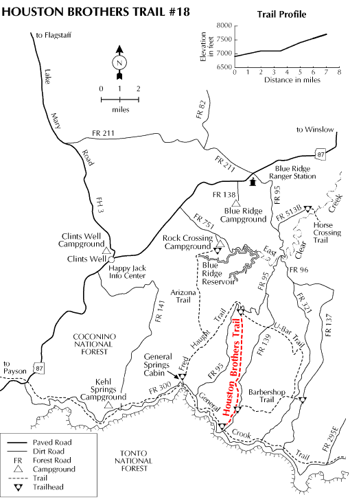
To hike Location: 65-miles (about 2 hours) south of Flagstaff in Mogollon Rim country's cool pines.
Access: Northern Trailhead. Drive about 55-miles south of Flagstaff on Forest Highway 3 (Lake Mary Road). Drive north 9 miles on AZ 87 to FR 95. Turn south (right) about 11-miles to FR 139A. Turn left on 139A and go 0.2-miles to a large trail sign with Fred Haught Trail. Also near the large sign is a small oak sign (on the east side of the road) with Pinchot Cabin on it. The road is obliterated to the cabin, but there are signs with Houston Brothers Trail on them once you hike down to the cabin.
Southern Trailhead. Drive about 55-miles south of Flagstaff on Forest Highway 3 (Lake Mary Road). Drive north 9-miles on AZ 87 to FR 95. Turn south (right) about 9-miles and turn left on FR 139. Continue 9 more miles on FR 139 and turn right (west) on FR 300. Go 0.1 (1 tenth) mile to Houston Brothers Trailhead sign.
FH 3 and AZ 87 are paved. FR 95 is graveled and suitable for passenger vehicles except during winter when it is closed.
 Route Editor

 For much of its length the Houston Brothers Trail wanders along the bottom of Houston Draw, a picturesque little valley through which a spring-fed perennial stream flows. The scenery here is mostly pastoral with a few photogenic rock outcrops and aspen groves to remind you that you're in rim country.
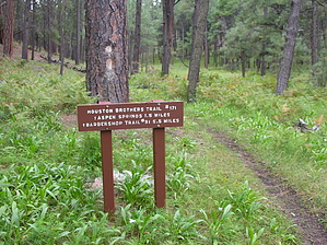


