 Route Editor

| Guide | ♦ | 144 Triplogs | 14 Topics |
details | drive | no permit | forecast | 🔥 route |
stats |
photos | triplogs | topics | location |
| 1.3k | 144 | 14 |
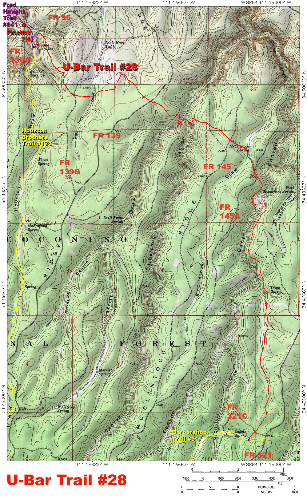
Where in blazes? by PrestonSands  Overview OverviewThe U-Bar Trail #28 is part of the Coconino National Forest's Cabin Loop Trail system on Arizona's Mogollon Rim. Once part of a network of trails used by early ranchers and the forest service, the route of the historic U-Bar Trail was marked by blazes (notches), cut into the bark of trees. Following the route of this trail is the only real challenge. One must keep a constant eye out for blazes, consisting of two notches deeply cut into the bark of a tree, one on top of the other. Some areas are marked by cairns and small signs indicating "Cabin Loop Trail". A well-trodden footpath is a rare sight on this hike. I highly recommend downloading and using gps joe's excellent and highly accurate U-Bar Trail gps route. Or, at the very least, bring a copy of this topo map.
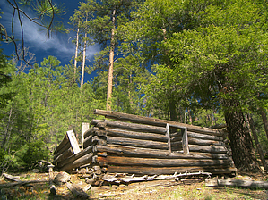
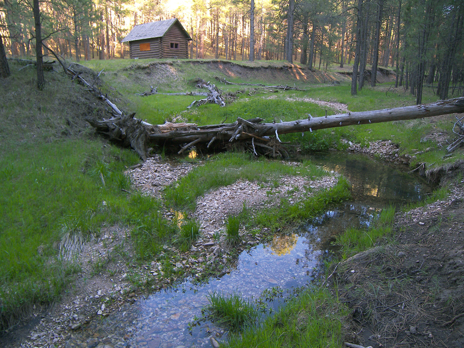
Warning Many of the roads that access this trail are closed during the winter due to snow. If you are in doubt, check with the forest service for road conditions before you go. Camping There are many outstanding campsites along the U-Bar Trail. Water will most likely be found at Houston Draw, Barbershop Canyon, Dane Canyon, and Dane Spring, but check with the forest service for water conditions before planning a trip to the area. Hike From the Pinchot Trailhead parking area (mile 0.0 for this description), head downhill along the Fred Haught Trail #141, as it follows an old road south. At 0.3 miles, the Fred Haught Trail terminates at the historic Pinchot Cabin. An early forest ranger's residence dating from the early 1930s, Pinchot Cabin is set in a small, scenic meadow at the bottom of Houston Draw. Seasonal Houston Creek flows alongside the old log cabin. The signed U-Bar Trail begins near the cabin and begins to follow another old road that climbs north up the east side of Houston Draw. Once out of Houston Draw, the U-Bar Trail turns southeast to continue climbing the road and reaches a "T" junction at 1.05 miles. Go right at the "T". The road passes a stock tank and soon reaches another "T" junction at about 1.35 miles. The trail leaves the road behind at the "T" and goes straight (east) to cross Dick Hart Draw. Bending north at a large brown water tank at 1.8 miles, the trail begins to follow the route of a primitive, old road. At 2.0 miles, the U-Bar Trail leaves the road on the right and turns southeast to travel through a park-like forest of mature ponderosa pines. The trail makes a perpendicular crossing of forest road 139 at 2.5 miles, then heads down the south side of a broad ridge towards Barbershop Canyon. Where the U-Bar Trail drops into Barbershop Canyon, blazes give way to a well-built trail along weathered walls of Coconino Sandstone, shaded by tall Douglas-firs. The U-Bar Trail crosses Barbershop Canyon, where it joins Merritt Draw, then makes a switchback ascent up the east wall. Once on top, the trail jumps over an ancient logging road, then continues east to meet forest road 145, at about the 3.8-mile point. Cross forest road 145 and continue downhill on a spur road to the large marshy meadow at McClintock Spring. The road turns south to cross McClintock Draw and climbs to meet forest road 145A in a saddle before continuing southeast to descend into Dane Canyon. Once again, the U-Bar Trail becomes well defined as it drops into the beautiful fir-lined canyon. The trail crosses a grassy flat at an "S" curve in the bottom of Dane Canyon, then switchbacks up its east side. For the next mile, the U-Bar Trail contours south along a densely wooded shelf, high above Dane Canyon. The trail reaches Dane Cabin at about the 6 mile point, shortly after crossing through a fence. Dane Cabin, said to be author Zane Grey's hunting cabin, is a decaying log structure set amongst towering Douglas-firs. Adjacent to the cabin, the ice-cold waters of Dane Spring flow from a cave in the Kaibab Limestone and form the headwaters of a little creek. Across the creek from the cabin, three trails diverge to the south. Take the far-right branch. The U-Bar Trail will travel due south to make a gentle, mile-long ascent, along a shallow gulch wooded with white firs, giant ponderosas, and occasional aspens. At about 7.2 miles, the trail leaves the gulch near its head to climb a low ridge, where you will need to keep a sharp eye out for blazes. Leveling off after the short climb up the ridge, the trail turns southwest and crosses forest road 321C. One-tenth of a mile later, the U-Bar Trail comes to an end in a shallow, maple-filled draw, where it meets the Barbershop Trail #91. Turn west onto the Barbershop Trail to continue the Cabin Loop, or turn east for a 0.1-mile hike out to forest road 321, if you have left a shuttle vehicle there.
Check out the Official Route and Triplogs. Leave No Trace and +Add a Triplog after your hike to support this local community. One-Way Notice This hike is listed as One-Way. When hiking several trails on a single "hike", log it with a generic name that describes the hike. Then link the trails traveled, check out the example. | |||||||||||||||||||||||||||||||||||||||||||||||||||||||||||||||||||||||||||||||||||||||||||||||||||||||||||||||||||||||||||||||||||||||||||||||||||||||||||||||||||||||||||||||||||||||||||||||||||||||||||||||||||||||


