Overview
The trail descends from Sowats Point, crosses Sowats Canyon, and then descends into Jumpup Canyon where it joins Trail #41.
Hike
This trail is located within Kanab Creek Wilderness. As it descends from Sowats point the trail offers a panoramic view of Sowats and Jumpup Canyons while dripping 2,000 feet among vermilion-colored cliffs interspersed with natural rock sculptures, pockets of juniper and pinyon and steep, molded sandstone canyons. At the base of the Point, the trail follows a sandy bench to the edge of Sowats Canyon, then crosses it.
After leaving Sowats, the trail winds its way around the Point and enters Jumpup Canyon. The Ranger Trail to Kanab Creek joins Trail #8 here, allowing the hiker to continue up Jumpup Canyon until it meets FR 423. Kwagunt Hollow and Sowats Canyon are popular accesses to Kanab Creek and the Colorado River. Because of the steep-sided and narrow pathway on this trail, riders should use only experienced trail horses. This trail is in a remote area, with limited water, high summer temperatures, and extremely rugged terrain. It is therefore recommended that specific and current information be obtained from the Visitor Center.
When hiking several trails on a single "hike", log it with a generic name that describes the hike. Then link the trails traveled, check out the example.
WARNING! Hiking and outdoor related sports can be dangerous. Be responsible and prepare for the trip. Study the area you are entering and plan accordingly. Dress for the current and unexpected weather changes. Take plenty of water. Never go alone. Make an itinerary with your plan(s), route(s), destination(s) and expected return time. Give your itinerary to trusted family and/or friends.
Permit $$
no fees or permits reported
if incorrect tell us about it
Directions
Road
High Clearance possible when dry
To hike Access: 1/4 mile south of Visitor Center on AZ 67, turn west on FR 461. Continue west on FR 461 and 462 for about 9 miles to FR 422. Turn south on 422 and go 11.5 miles (5 miles beyond Big Springs), then turn west on FR 425. Go about 8 miles and turn right on FR 233. Follow 233 about 9 miles to the trailhead. The road ends at Sowats Benchmark, about 0.5 miles beyond the trailhead.
Travel Time: Two hours from North Kaibab Visitor Center.
Road Conditions: Approximately 38 miles of gravel and dirt roads, the last 8 miles of which are suitable for high-clearance vehicles only.
 Route Editor


 Overview
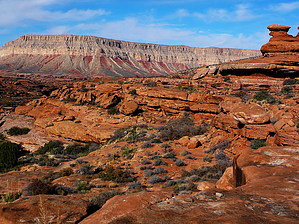


