Route Editor

| Guide | ♦ | 50 Triplogs | 1 Topic |
details | drive | permit | forecast | route |
stats |
photos | triplogs | topic | location |
| 481 | 50 | 1 |
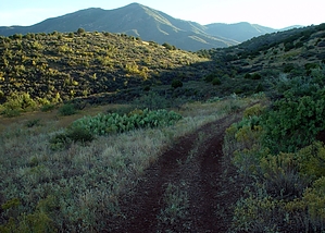
Panoramic and then some by gpsjoe  2015 Update 2015 UpdateThe lower end of the trail was re-routed sometime in the past couple of years and the parking area has been moved. Formerly you parked and continued up the road a ways to the trail start. Now, directly from the parking area head SW towards the mountain. Perhaps Prescott... The day began when my favorite hiking partner sent a 4:00 AM email saying she wasn't feeling well and would not be hiking that day. I was ready to go but my 2 WD Honda would not get to that trailhead. So I quickly went in search of an alternate destination to hike. Somehow I came up with the Black Canyon trail located near Cottonwood.
The Hike The trailhead and the lower part of this trail are unimpressive. Almost no vegetation and the only good thing to see are views of Cottonwood and Sedona red rocks from a higher elevation. So I was not optimistic at the beginning of this hike. The trail starts on a dirt road and continues for 1.5 miles before a real foot trail begins. Not much to see here but good views of the Black Canyon start immediately after that. The next 3.5 miles of hiking take you through the Black Canyon while gaining in elevation from 4,200 at the trailhead to 6,100 at the first saddle where the trail tops out. You now have moved away from civilization as Cottonwood and Sedona are no longer visible. The Black Canyon is impressive and vegetation increases with increasing elevation. Snow-capped mountains can be seen in the distance. The trail was easy to follow but was overgrown for about a mile of the mid-section of the hike. Water can be heard rushing through the canyon bottom during most of the climb up the canyon. I was tempted to take a side trip to the bottom of the canyon to get views from there, but I wanted to do the whole trail. This turned out to be the right decision. After reaching the first saddle at 6,100 feet the trail takes you down to 5,900 feet while entering a pine forest at the top. Everything about this part of the hike was completely different from the first five miles and it was beautiful. Much to my surprise the trail then follows along a creek that is flowing eagerly at this time. There is patchy snow along this part and that makes for good pictures. This section goes on for about 1.5 miles as you do a gradual climb to 6,400 where near the end I hiked through very desirable campground areas near the creek and onto Forest Road 413, the end of the Black Canyon trail and the turnaround point for this hike. Since I meandered around for about a mile at the top and didn't want to leave there, I started back at 3:00 PM thinking I was cutting it close as far as the dark was concerned. But I knew the downhill was fast and I was through taking pictures, I thought. As I came back over the first saddle I noticed I was dealing with the afternoon sun that cast a whole different light on the canyon so I started shooting more. An hour later at around 4:30 PM, the sun was going down making for some dim or dark scenes near me but the setting sun just lit up the Red Rocks of Sedona in the distance. I tried my best to get some shots of these and they are included in my photoset. So, what I thought was going to be an exercise hike with not much to see turned out to have some very nice sections and great scenery. I would rate this a very good hike (not spectacular but so what). It is recommended, just don't judge it by the trailhead or the first 1.5 miles. Getting there from Phoenix take I-17N to 260W at the Camp Verde exit to the left on Ogden Ranch Road about a mile before the entering Cottonwood sign. Take this good dirt road for 4.2 miles to the trailhead. Hike in 0.1 miles to the rusted car body, turn left down the dirt road, and follow it until it turns into a trail and beyond. Shortly after that, there is a trail going off to the left that is not the Black Canyon trail. It seems to go to a viewpoint a little below the real trail. The rest of the trail is easy to follow. Near the end, dirt road-like paths reappear. There is one that goes sharply right. Continue straight here. Entering a campground hike through it and continue on the faint trail or through the woods 0.2 miles to FR413 and find the trail sign. I did 14.1 miles on this hike. That included about 0.5 miles of wandering around at the top. This hike can be done as a car drop or key swap with cars on the top and bottom. It is a spectacular scene if you can be coming down the trail when the sun is setting. Prescott FS Details This is an excellent hiking and riding trail that provides panoramic views of the Verde Valley, the red rock country above Sedona, and as far as the San Francisco Peaks. Hiking this trail from the bottom to where it meets the Allen Spring Road can be tough since there is an elevational gradient of over 2,200 feet. This trail is a good choice for horseback riders. The trail is also a good one for planning a one-way, downhill hike with vehicles left at both ends of the trail. There are many connecting trails and roads that provide a variety of ways to explore this country either on foot or horseback. Maps, other resources: Prescott National Forest, east half; U.S.G.S. topographic 7.5" quads for Cottonwood. Trail layout: The trail begins at an elevation of about 4,100 feet at Quail Springs. It climbs steadily along the slopes overlooking Black Canyon, finally entering that drainage at about mile 4.5. From there the trail turns sharply northwest up Gaddes Canyon to where it ends on FR 413 at an elevation of 6,400 feet Check out the Official Route and Triplogs. Leave No Trace and +Add a Triplog after your hike to support this local community. | ||||||||||||||||||||||||||||||||||||||||||||||||||||||||||||||||||||||||||||||||||||||||||||||||||||||||||||||||||||||||||||||||||||||||||||||||||||||||||||||||||||||||||||||||||||||||||