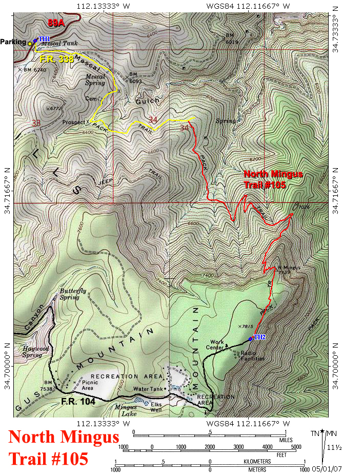
The North Mingus Trail #105 climbs the north slope of Mingus Mountain, in Arizona's Black Hills. Two stories exist concerning the naming of Mingus Mountain. One story claims the mountain was named for the Domingus brothers, who reportedly had a sawmill on top of the mountain. The other story reports that a man named William Mingus had a mine somewhere in the area. According to Will C. Barnes' Arizona Place Names, Mescal Gulch (which the hike follows for its first couple of miles) was the site of a bloody, two-day battle between the Hualapai and Yavapai tribes, sometime in the distant past. This hike describes Forest Road 338 and the North Mingus Trail. If you have a four-wheel-drive vehicle with high clearance and choose to drive to the end of forest road 338 (I wouldn't recommend it) instead of hiking it, you can cut 3.6 miles off of the round trip distance.
From the Prescott National Forest sign next to Highway 89A, cross the highway, and begin hiking down Mescal Gulch on forest road 338. Forest road 338 stays on the south side of the creek. At 0.65 miles, the road comes to Mescal Spring, which is enclosed by a low rock wall, near a large box elder tree. There is a parking area here that would be a good stopping point for those without four-wheel drive. The road forks here; go right, up the steep, rocky road. Forest road 338 soon rounds a corner, levels off somewhat, and passes a small, overgrown cemetery on the right. Shortly past the cemetery, at the one mile point (34.72335 N, 112.13492 W), the road forks again; make a hard left and cross the creek bed. FR 338 now contours along through the forest on the north slopes of Mingus Mountain and becomes increasingly primitive. Views to the north include the meadow at Mescal Spring, and the reddish, rocky canyon of Mescal Gulch. At 1.78 miles, road 338 reaches the northern end of the North Mingus Trail. A cairn and a brown fiberglass signpost mark the junction (34.72342 N, 112.12363 W). There is a turn around/parking area a few hundred feet beyond here, for those who have driven this far.
Turn south onto the North Mingus Trail #105, and follow it up the slope through the thick oak brush. The summit of Mingus Mountain comes into view as the trail makes a gradual descent to a canyon bottom filled with tall ponderosa pines. The trail soon crosses another small, maple filled drainage before climbing up a brush-covered ridge. Woodchute Mountain comes into view here, as the trail switchbacks up the ridge. At 3.1 miles, the trail climbs around another steep drainage, directly below the summit of Mingus Mountain, before meeting up with trail 105A in a lofty saddle.
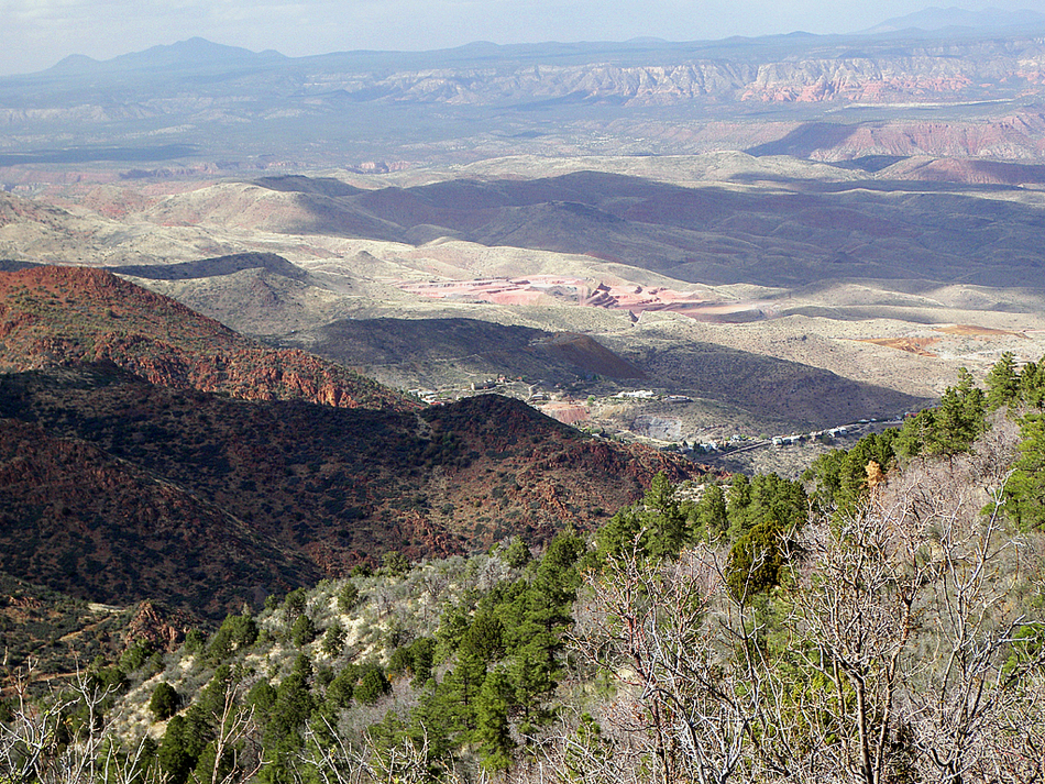
The North Mingus Trail now heads south up the ridge and enters the forest on Mingus Mountain's north face. Outstanding views of Jerome, Sycamore Canyon, and the Sedona area exist here, as the trail switchbacks up the ridge. Aspens, bigtooth maples, and beautiful fir trees shade the trail along this stretch. The trail soon reaches the flat top of Mingus Mountain and heads south into the forest. About 0.2 miles after hitting the top, the trail arrives at a double rock cairn (34.70651 N, 112.11435 W), where the trail splits. Take the left fork to the east. The North Mingus Trail soon reaches the sheer eastern edge of Mingus Mountain, where the awesome views return. A couple of hang glider launch ramps are passed before the trail comes to an end at forest road 104. This location serves as the upper trailhead.
WARNING! Hiking and outdoor related sports can be dangerous. Be responsible and prepare for the trip. Study the area you are entering and plan accordingly. Dress for the current and unexpected weather changes. Take plenty of water. Never go alone. Make an itinerary with your plan(s), route(s), destination(s) and expected return time. Give your itinerary to trusted family and/or friends.
Only trailheads with six "amenities" have fees. Amenities are picnic tables, trash, toilet, parking, interpretive signing and security.
Directions
Road
Paved - Car Okay
To hike LOWER TRAILHEAD ALONG HIGHWAY 89A (34.73095 N, 112.14121 W): From the Highway 89/Highway 89A junction just north of Prescott, head east on Highway 89A, towards Jerome, for 21.9 miles. At the bottom of Mescal Gulch (milepost 339.6), there is a pull-off area on the left, near the Prescott National Forest sign. Forest Road 338, which is marked by a brown fiberglass signpost, starts on the right side of the highway here and heads down Mescal gulch.
UPPER TRAILHEAD ON MINGUS MOUNTAIN (34.70259 N, 112.11641 W): From the Highway 89/Highway 89A junction just north of Prescott, head east on Highway 89A, towards Jerome, for 18.9 miles. At the top of the mountain (milepost 336.6), turn right onto forest road 104 (dirt-can be muddy after wet weather), and follow it for 2.5 miles to the Mingus Campground. Turn left (north) at the "T" and follow forest road 104 for another 0.7 miles to its end, where the North Mingus Trail begins.
 Route Editor

 The North Mingus Trail #105 climbs the north slope of Mingus Mountain, in Arizona's Black Hills. Two stories exist concerning the naming of Mingus Mountain. One story claims the mountain was named for the Domingus brothers, who reportedly had a sawmill on top of the mountain. The other story reports that a man named William Mingus had a mine somewhere in the area. According to Will C. Barnes' Arizona Place Names, Mescal Gulch (which the hike follows for its first couple of miles) was the site of a bloody, two-day battle between the Hualapai and Yavapai tribes, sometime in the distant past. This hike describes Forest Road 338 and the North Mingus Trail. If you have a four-wheel-drive vehicle with high clearance and choose to drive to the end of forest road 338 (I wouldn't recommend it) instead of hiking it, you can cut 3.6 miles off of the round trip distance.


