Prescott NF Writes
This trail, which borders but does not enter the Woodchute Wilderness, was originally built many years ago with a bulldozer. The purpose was to develop and gain access to the water tanks in Martin Canyon. These include Rick Tank, Martin Canyon Tank, Turkey Tank, and Hickey Tank. This old road now serves as part of the Forest trail network.
Starting near Turkey Tank, the trail descends the small drainage to the northeast for 0.7 miles to where it enters Martin Canyon. From Martin Canyon Tank, the trail heads northwest, staying in the canyon bottom for almost its entire length. At about mile 4.25, the trail turns sharply south for 0.6 miles to where it ends at James Tank.
Use restrictions
Motor vehicles less than 40" wide are permitted.
Maps
Prescott National Forest, west half; U.S.G.S. topographic 7.5' quads for Hickey Mountain.
When hiking several trails on a single "hike", log it with a generic name that describes the hike. Then link the trails traveled, check out the example.
WARNING! Hiking and outdoor related sports can be dangerous. Be responsible and prepare for the trip. Study the area you are entering and plan accordingly. Dress for the current and unexpected weather changes. Take plenty of water. Never go alone. Make an itinerary with your plan(s), route(s), destination(s) and expected return time. Give your itinerary to trusted family and/or friends.
Only trailheads with six "amenities" have fees. Amenities are picnic tables, trash, toilet, parking, interpretive signing and security.
Directions
Road
Strictly 4x4
To hike Access and trailhead location: The access to the trail is from Highway 89A and the Potato Patch Campground. Go to the Potato Patch Campground just east of the summit on 89A. Then take FR 106 west for 2.0 miles past Hickey Tanks to the intersection of 106A and FR 9710W. Take FR 9710W north for 0.6 miles to where the trailhead is located just west of Turkey Tank.
Travel time: 45 min. from Prescott Road condition: Paved, then 4WD to the trailhead.
 Route Editor


 Prescott NF Writes
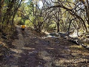


