 Route Editor

| Guide | ♦ | 56 Triplogs | 0 Topics |
details | drive | no permit | forecast | route |
stats |
photos | triplogs | topics | location |
| 247 | 56 | 0 |
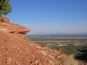
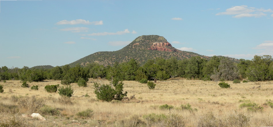
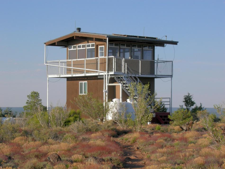
Overlooked Overlook & Lookout by Al_HikesAZ  Overview OverviewRed Butte is the most prominent feature on the landscape between Flagstaff, Williams, and the Grand Canyon. Most people rush by it on their way to and from the Grand Canyon and pay it no mind. The National Forest Service description is excellent, so I will mostly give you my musings and observations. A friend recommended this hike, so I read about it in "50 Hikes in Arizona: Walks, Hikes, and Backpacks through Sky Islands and Deserts in the Grand Canyon State" by Martin Tessmer and decided to hike it.
The Kaibab forest in this area is comprised of juniper trees and some fir as you get higher. The climate is a little cooler than the Grand Canyon South Rim, about 20 miles north. There are campsites scattered throughout the forest. I have seen elk throughout this forest, and I saw elk hoofprints on the trail. Hike A well-defined and maintained trail starts on the western base. You start up in a series of gentle switchbacks. You have vistas stretching for at least a hundred miles in all directions. The junipers provide some shade and a forest feeling. At about 3/4 mile, the switchbacks become a little steeper, and you get some cardio workout. At 1 1/4 mile, you top out on the butte and see the Forest Service Lookout Tower. A notice on the lookout tower identifies it as a National Historic Site. This is a working fire lookout, so please don't disturb the Ranger. There is a picnic table so relax and enjoy the views. The views in all directions are magnificent, especially to the San Francisco Peaks to the southeast. You really can't see much of the Grand Canyon from here. This should be a great hike with children or dogs. Kaibab FS Details Red Butte is a unique geological formation of the Coconino Plateau in northern Arizona. The dark layer of rock at its top is a basaltic cap that is a remnant of past volcanic activity. It has protected the butte from the erosion experienced by the surrounding landscape. The plateau on which the butte is located consists primarily of Kaibab limestone, the rock that forms the top layer of the cliffs in the Grand Canyon. The lower portion of the butte is composed of the Moenkopi formation, a strata that is exposed in the Painted Desert. On top of this lies the Shinarump conglomerate, another Painted Desert Rock and then the cap of basalt. The top of Red Butte provides an excellent 360 degree view of the surrounding area, including the San Francisco Peaks. Caution should be taken in the summer months when rattlesnakes may be present on or along the trail. Red Butte is sacred to the Havasupai Indian Tribe, the only permanent residents of the Grand Canyon. Treat it with respect. Trail Layout: The Red Butte Trail climbs from 6,460 ft. (1970M) elevation at the trailhead to 7,326 ft. (2233M) elevation on top of Red Butte. For the first .75 mile, the trail climbs moderately and has only a few switchbacks. The last .5 mile ascends the steep, upper slopes of the butte and has several switchbacks and steep grades. The trail is well-marked and easy to follow. USGS Map: Red Butte Check out the Official Route and Triplogs. Leave No Trace and +Add a Triplog after your hike to support this local community. | ||||||||||||||||||||||||||||||||||||||||||||||||||||||||||||||||||||||||||||||||||||||


