 Route Editor

| Guide | ♦ | 2 Triplogs | 0 Topics |
details | drive | permit | forecast | route |
stats |
photos | triplogs | topics | location |
| 31 | 2 | 0 |
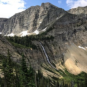
Trails to the Crypt by FOTG Crypt Lake is an iconic hike and destination in Waterton Lakes National Park. The trail to this unique alpine lake is famous for its ladder, tunnel and cable section that add a little adventure to this otherwise pretty straightforward hike. However, these fun little trail extras are by no means the highlight of this hike, as Crypt Lake remains the real attraction. Crypt Lake is an especially scenic and very unique alpine lake, as it lacks a real above ground outlet stream, however, it still feeds a very robust waterfall that drops several hundred feet from the cirque that houses Crypt Lake. This waterfall is perhaps as scenic and unique as the lake itself and is fed through an underground spring that gets its supply of water from somewhere below the surface of Crypt Lake. Getting There The trailhead for Crypt Lake and the trail that shares its name is called Crypt Landing. It is most conveniently reached via a water taxi that operates out of Waterton Village. At the time of the writing of this description it was $25.00. There are two trips to the trailhead in the morning and two pick ups in the afternoon. Therefore, you will be on a bit of a schedule when doing this hike. Camping at the lake is not permitted. Inquire at the visitor center for more information and verification of prices and times.
As mentioned in the overview, the hike to Crypt Lake is pretty straightforward, apart from the trail extras. The trail starts immediately with a pretty good uphill climb, however, it is made considerably more bearable by a series of several switchbacks. After about a mile, the steepness subsides some and you don't really start climbing again until about 3.5 miles in. This stretch of trail is no longer under the trees and finally offers some nice views of the rugged canyon and surrounding mountains. Eventually, you will start to see the majestic falls that spill 500 feet down the sheer cliff and cirque that hold Crypt Lake. At about 4.5 miles you will reach a ladder that climbs to a tunnel only tall enough to crouch in. After navigating the tunnel, you will find yourself with a great view of Crypt Falls and along a cliff with a somewhat narrow tread. There is a cable in place here and one should use as needed to complete the short section. After the cable, the trail continues its steady climb to Crypt Lake, where it ends in a wooded section along its shore. Return the way you came, or make a small loop near the end of your hike with the steep Hellsroaring Canyon Trail. Check out the Official Route and Triplogs. Leave No Trace and +Add a Triplog after your hike to support this local community. One-Way Notice This hike is listed as One-Way. When hiking several trails on a single "hike", log it with a generic name that describes the hike. Then link the trails traveled, check out the example. | ||||||||||||||||||||||||||||||||||||||||||||||||||||||||||||||||||||||||||||||||||||||||


