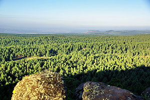
This is a hike to near the top of Summit Mountain where you can enjoy the expansive views. From the end of the trail, you will find an excellent vista of the forest and rim country as it falls off to the headwaters of the Verde River and the distant Mingus and Bradshaw Mountains. Most of the trail was originally built in 1916 to access a fire lookout point. After some 50 years of abandonment, it was rebuilt in 1997 to offer an opportunity to enjoy the pleasurable walk to the top of the mountain.
WARNING! Hiking and outdoor related sports can be dangerous. Be responsible and prepare for the trip. Study the area you are entering and plan accordingly. Dress for the current and unexpected weather changes. Take plenty of water. Never go alone. Make an itinerary with your plan(s), route(s), destination(s) and expected return time. Give your itinerary to trusted family and/or friends.
Permit $$
None
Directions
Road
FR / Dirt Road / Gravel - Car Okay
To hike From Williams, take County Road 73 (4th Street) south 8.5 miles to FR 110; turn left onto FR 110 and continue east 2 miles to FR 706; turn right onto FR 706 and follow the gravel-surfaced road about a half a mile to the parking area on the right.
Travel Time: About 20 minutes from Williams to the trailhead.
Road Condition: Paved and all-weather graveled roads suitable for passenger cars.
 Route Editor


 This is a hike to near the top of Summit Mountain where you can enjoy the expansive views. From the end of the trail, you will find an excellent vista of the forest and rim country as it falls off to the headwaters of the Verde River and the distant Mingus and Bradshaw Mountains. Most of the trail was originally built in 1916 to access a fire lookout point. After some 50 years of abandonment, it was rebuilt in 1997 to offer an opportunity to enjoy the pleasurable walk to the top of the mountain.