2015: Switchbacks were added to sections of this trail. It no longer passes Dripping Springs.
Stats: Page stats are from the more popular bottom trailhead. Going up this trail is 2,800 feet of AEG. Going down this trail still nets 1000 feet AEG. The bottom of this trail is not only warmer it's more exposed.
There are several ways to savor this beautiful hike. The first is by far easier way, from Rte 87 (MP 279) and head south down the rim about 7.5 miles to the Pine TH. If you want to live on the edge and hike something a bit more difficult, then hike it from the Pine TH UP the rim, a 2800 ft elevation gain. Mark and I decided we wanted to take the challenging route so we left his vehicle at the northern terminus and took my car to the Pine TH in order to do a shuttle hike.
It was a beautiful morning with a 45-degree temp when we left the Pine TH at 6:30 AM... a three-quarter full moon hung out to our west as the rosy glow from the rising sun to the east. Colors splashed across the sky in all hues of purple, red, and orange as the sun rose over the rim, then gave way to our perfect chalcedony blue sky. About 1/4 mile from leaving the Pine TH, we reached the intersection of the Highline Trail but continued on our quest up Pine Canyon. It is a well-traveled and well-blazed trail although we saw no other hikers today.
The terrain is steep and rocky as you make your way up the rim. But as you steadily climb you have awesome views of the valley below~~~Payson, the Mazatzal's to your south and west, Milk Ranch Point to your east. Magnificent views. The trail gains 2000 feet through some beautiful areas of maples, box elders, and Gambel oaks which are just starting to change color with the season when we hiked it today. Passed the signs for Cinchhook and Stradling Canyons as we approached the crest of the Mogollon Rim but we weren't interested in any side trip~~~It took us 5.5 hours to climb this although we spent a good 1/2 hour resting on a ledge looking over the valley and had lunch.
This was a beautiful and challenging hike up the Mogollon Rim. The only casualty on this trip was my 35mm camera which was lost after the strap broke and it crashed into the rocks below. All my pictures were lost.
When hiking several trails on a single "hike", log it with a generic name that describes the hike. Then link the trails traveled, check out the example.
WARNING! Hiking and outdoor related sports can be dangerous. Be responsible and prepare for the trip. Study the area you are entering and plan accordingly. Dress for the current and unexpected weather changes. Take plenty of water. Never go alone. Make an itinerary with your plan(s), route(s), destination(s) and expected return time. Give your itinerary to trusted family and/or friends.
Permit $$
None
Directions
Road
FR / Dirt Road / Gravel - Car Okay
To hike NORTH Trailhead: From Payson head north on SR 87. Pass the towns of Pine & Strawberry. About 1 mile past the 87/260 intersection near mile marker 279 turn right and go through the gate. (Please close the gate entering & leaving)
SOUTH Trailhead: From Payson head north on SR87. Just before entering the town of Pine, you will see a HUGE sign indicating "Pine Trailhead" on the right.
 Route Editor


 2015: Switchbacks were added to sections of this trail. It no longer passes Dripping Springs.
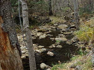


