Route Editor

| Guide | ♦ | 1 Triplog | 0 Topics |
details | drive | no permit | forecast | route |
stats |
photos | triplog | topics | location |
| 17 | 1 | 0 |
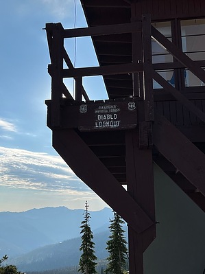
A Heavenly Ascent by FOTG A lookout and cabin were originally built on Diablo Mountain in 1926 and a remodel of some type occurred in the 1930s. The lookout was manned by the forest service until the late 70s and then it went unoccupied until 2012 when a group of volunteers connected to the Powell Ranger District Fire Organization began manning the lookout from July to September. The current lookout is not the original lookout, as it was built in 1965 to replace the original lookout. The lookout is in excellent condition and still serves an important role in fire detection within the area. Hike: The hike starts from the trailhead labeled Elk Summit Camp Loop A. Begin on the Big Sand Lake Trail. The actual trail does not start from the informational kiosk and register area anymore, as a large blow-down blocks the trail only a few hundred feet in, rather the trail now begins from the horse lot area.
From the intersection, the trail weaves its way through the snags and makes a rightward turn to gain the ridgeline of Diablo Mountain. The trail climbs through the snags and remains pretty exposed to the sun through here, but some excellent views of the idyllic Horse Heaven Meadow below that somewhat helps to redeem this portion of the trail. The forest reappears as you traverse to the shaded slopes of Diablo Mountain, some of the best views of the hike emerge during this final push to the summit. The spur trail coming in from the right goes to Diablo Spring, which is said to be generally reliable through late summer. The trail will briefly level out at a saddle-like area where you get your first good view of the summit and the final climb to get there. A series of gentle switchbacks will take you the rest of the way. The summit occupies a dramatic setting perched above on some high cliffs (exercise caution when taking in the views along the cliffs and consider leashing pets) and offers a pretty stunning vantage point of the surrounding wilderness and notable peaks. Duck Lake sits just below you and to your south are the stunning Goat Heaven Peaks and Lakes. Grave Peak dominates the skyline to the west and Bitterroot aficionados may be able to identify some of the many prominent peaks along the Bitterroot Divide to the east. After enjoying the views from the summit and taking an earned break, return the way you came.
Check out the Official Route and Triplog. Leave No Trace and +Add a Triplog after your hike to support this local community. | |||||||||||||||||||||||||||||||||||||||||||||||||||||||||||||||||||||||||||||||||||||||||||||