username
X
password
register
for free!
help
 This is likely a great time to hike this trail!  Check out "Preferred" months below, keep in mind this is an estimate.
 

Dodge Point Trail, ME

Guide 1 Triplog  0 Topics
  4 of 5  
Fav
Wish
0
details
drive
no permit
forecast
route  
stats
photos
triplog
topics
location
12 1 0
Statistics
tap row or icons for details
Difficulty 1.5 of 5
Distance Network 4.2 miles
Trailhead Elevation 167 feet
Elevation Gain -134 feet
Accumulated Gain 166 feet
Avg Time Hiking 1-3 hours
Kokopelli Seeds 4.75
unreported if dogs are allowed
editedit > ops > dogs to adjust
feature photo
Photos Viewed All MineFollowing
12  2018-08-13 rayhuston
Author
author avatar Guides 1
Routes 448
Photos 4,407
Trips 939 map ( 8,048 miles )
Age 68 Male Gender
Location Gilbert, AZ
Co-Author
co-author avatarGuides 16,843
Routes 17,472
Photos 24
Trips 1 map (6 Miles)
Age 28 Male Gender
Location HAZ, TrailDEX
Associated Areas
list map done
Mid Coast Region
Historical Weather
Trailhead Forecast
Radar Map
Expand Map
Preferred Sep, May, Jun, Aug
Sun  5:08am - 6:04pm
Official Route & 1 Rt
 
0 Alternative


this land is your land
by rayhuston & HAZ_Hikebot

 Likely In-Season!
The preserve land has seen human activity since prehistoric times. In the 19th century, the land was cleared for farming, resulting in the creation of the stone walls found throughout the property. The landscape is dominated by red pine.


Hike
The Dodge Point Trail is a combination of forest road (the “Old Farm Road”) and spur trails that allow you to stay close to the river. It starts on the farm road heading east towards the river, then bends south along the river. After 1.5 miles or so the trail turns west then back north to return to the trailhead for a nice 3 mile plus loop over easy terrain.
remove free decal offer
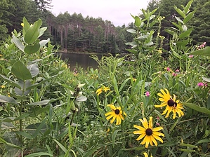
You are under a canopy of trees typical of Maine throughout the hike. The river is on your left for about a third of the hike with a few worn paths you can use to go down to play in the water.

2018-08-14 rayhuston & HAZ_Hikebot
  • Brochure  Map
    guide related
    Brochure Map
  • Brochure  Map - 2
    guide related
    Brochure Map - 2


Check out the Official Route and Triplog.
Leave No Trace and +Add a Triplog after your hike to support this local community.
WARNING! Hiking and outdoor related sports can be dangerous. Be responsible and prepare for the trip. Study the area you are entering and plan accordingly. Dress for the current and unexpected weather changes. Take plenty of water. Never go alone. Make an itinerary with your plan(s), route(s), destination(s) and expected return time. Give your itinerary to trusted family and/or friends.

 Permit $$
no fees or permits reported

if incorrect tell us about it


 Directions
or
 Road


To hike
page created by HAZ_Hikebot on Mar 09 2010 4:51 pm
 90+° 8am - 6pm kills
helpcorrectionissue

end of page marker