Located along the rim of the Grand Canyon and connecting five large "Points" of land which overhang the Canyon and the Arizona Strip. The five "Points" are: Parissawampitts, Fence, Locust, North Timp, and Timp. Each offers a different view and perspective of Grand Canyon features such as Powell Plateau, Steamboat Mountain, Tapeats Amphitheater, and Great Thumb Mesas, as well as the Mt. Trumbull region of The Arizona Strip. In addition to the areas along the rim, the trail passes through a forest of old-growth Ponderosa pine and drops into several steep-sided canyons filled with groves of aspens and small meadows.
When hiking several trails on a single "hike", log it with a generic name that describes the hike. Then link the trails traveled, check out the example.
WARNING! Hiking and outdoor related sports can be dangerous. Be responsible and prepare for the trip. Study the area you are entering and plan accordingly. Dress for the current and unexpected weather changes. Take plenty of water. Never go alone. Make an itinerary with your plan(s), route(s), destination(s) and expected return time. Give your itinerary to trusted family and/or friends.
Permit $$
no fees or permits reported
if incorrect tell us about it
Directions
Road
To hike Parissawampitts: Go 26.5 miles south of Kaibab Plateau Visitor Center on AZ 67, turn right on Forest Development Road (FDR) 22 for 10.5 miles to FDR 206. Turn left and continue on FDR 206 for 3.5 miles and turn right on FDR 214 and follow it for 8 miles to Parissawampitts Viewpoint.
Fence: Continue on FDR 206 for an additional 1.5 miles to the FDR 271, turn right for .1 mile to FDR 294, continue on FDR 294 for .1 to FDR 293 and follow it to the trailhead in about 8 miles.
Locust: Follow FDR 294 for about 8 miles to the trailhead.
North Timp: From the junction of FDR 206 and 271, follow FDR 271 for 5 miles to FDR 271A, turn right and follow FDR 271A for 3 miles.
Timp: From the junction of FDR 206 and 271, follow FDR 271 for 8 miles to the trailhead.
 Route Editor

 This incredible trail ribbons a 16-mile section of the north rim of the Grand Canyon.
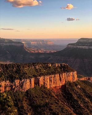


